Tricky wind outlook with a good westerly swell next week

Victorian Forecast by Craig Brokensha (issued Friday December 13th)
Best Days: Tomorrow morning, Sunday morning to the east, Friday morning to the east
Features of the Forecast (tl;dr)
- Easing SW swell over the weekend with variable tending fresh SE winds tomorrow, light E-E/SE on Sun ahead of sea breezes
- Small Mon with strengthening N/NE winds ahead of a strong S/SW change mid-late PM
- Moderate sized W'ly swell for Wed, peaking through the day, easing slowly Thu
- Fresh W/SW tending SW-S/SW winds Wed, E/S-SE Thu AM, freshening
- Smaller Fri with E-E/NE tending S/SW winds
Recap
The surf built all day yesterday as a mix of mid-period swell and larger groundswell filled in, generated by a strong low to the south-west of the state on Wednesday.
The morning was cleanest on the Surf Coast but the afternoon doable with the surf reaching the 6ft range under a moderate onshore breeze.
This morning the swell is still 4ft+ on the Surf Coast with mostly clean but slightly lumpy conditions and we’ll see the size continuing to ease through the day as winds shift S/SW and freshen over the coming hours (they've just done this).

Solid sets yesterday afternoon
This weekend and next week (Dec 14 - 20)
Looking at the weekend ahead, we’re expecting a slow downwards trend in swell and period thanks to weak but persistent frontal activity following the strong low on Wednesday.
The Surf Coast should ease back from 2-3ft tomorrow with 4ft+ sets to the east, smaller into Sunday.
Conditions look favourable for both coasts tomorrow with variable tending light, local offshore winds ahead of fresh SE sea breezes.
Sunday looks a touch better for locations east of Melbourne compared to the outlook on Wednesday with an E/SE-E breeze but smaller, easing surf.
The surf will bottom out into Monday and a strengthening NE tending N/NE breeze will create clean conditions to the east before a strong S/SW change moves through mid-late afternoon.
This change will be associated with the remnants of a strong mid-latitude frontal system pushing up towards and then under Western Australia, weakening once pushing through the Bight.
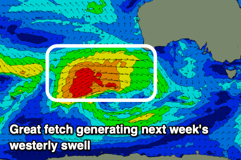
The earlier stages of this frontal progression will generate a great fetch of slow moving W/SW gales to the south-west of Western Australia from today through the weekend, with a moderate sized W’ly groundswell due to move in Wednesday and peak through the day.
The westerly angle will impact size and consistency on the Surf Coast but we should see sets coming in at 4ft across the magnets (smaller elsewhere) with 6ft to occ 8ft sets likely to the east, only easing slowly through Thursday.
Local winds on Wednesday look average and fresh from the W/SW, shifting SW-S/SW through the day and increasing a little with E/SE-SE winds on Thursday morning (less than ideal). More variable E-E/NE winds as the swell eases Friday looks to offer the best chance of a wave but we’ll review this Monday. Have a great weekend!
Comments
I’d say more like 8ft sets yesterday arvo, was definitely solid and the wind was into it a bit but still doable
Nice, I only had a quick glance at things into the afternoon.
due to the swell size a fabled left was doing its thing yesterday