Large stormy surf developing tomorrow, moderating from Friday through the weekend
South Australian Forecast by Craig Brokensha (issued Wednesday 9th May)
Best Days: No good days
Recap
A new W/SW swell due to fill in through yesterday afternoon came in ahead of schedule and much larger than expected with magnets on the Mid Coast with 3ft+ sets and variable winds creating pumping surf.
The South Coast was also great with a good sized swell and favourable winds most of the day.
This morning the swell has dropped back to a good clean 2-3ft off Middleton and a bumpy 1-1.5ft+ across the Mid Coast with deteriorating conditions. We'll see winds shift more W/NW across the South Coast through the day ahead of an evening SW change.

Today’s Forecaster Notes are brought to you by Rip Curl
This week and weekend (May 10 – 13)
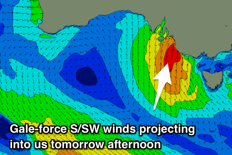
This evening's change will be linked to a strong and strengthening polar front projecting from south-west of us, right up into the South Coast tomorrow.
 A fetch of S/SW gales will move in a captured-fetch like motion, producing a large stormy S/SW swell that will build through tomorrow, largest late in the day.
We're likely to see stormy 6-8ft sets later in the day across most open locations but with strong to gale-force S/SW winds.
The Mid Coast will see stormy waves to 2ft with the strong S/SW breeze, reaching 3ft into the afternoon as the winds become strongest.
We should see winds back off through Friday as the storm moves off to the east, but a strong low pressure moving off the East Coast and stalling through the weekend will continue to project poor S'ly winds into the South Coast until Monday. Winds will be strong Friday and Saturday, more fresh from the S/SE Sunday.
This will create poor conditions as the S'ly swell eases back from the 6ft range Friday morning down South, back to sloppy and weak 3-4ft Saturday.
Sunday looks smaller again, and some new small inconsistent SW groundswell from the Indian Ocean should keep Middleton around 2-3ft, but with poor S/SE winds.
The Mid Coast will drop back quickly Friday from 2ft though with poor S/SW winds, tiny Saturday with a better S/SE breeze.
The inconsistent groundswell for Sunday may keep 1ft sets persisting on the Mid through the day with a SE offshore, fading back Monday.
Next week onwards (May 14 onwards)
Moving into early next week and it looks like we'll see SE winds lingering Monday as the background SW groundswell eases, while variable winds may be seen Tuesday morning ahead of a S/SE change overnight as a strong high slides in from the west.
This high looks to create average winds from the southern quadrant, spoiling a good new W/SW groundswell due Wednesday/Thursday but more on this in the next update.

