One small window before the wind hits
Victorian forecast by Craig Brokensha (issued Friday February 14th)
Best Days: Surf Coast tomorrow morning and Monday morning, exposed beaches Friday morning
Features of the Forecast (tl;dr)
- Moderate sized mid-period SW swell for later today, holding tomorrow AM ahead of a building S/SW windswell into the PM
- Gusty W/NW winds early tomorrow, strengthening from the SW tending S/SW from mid-late AM
- Moderate sized mid-period S/SW swell for Sun AM, easing into Mon
- Strong but easing S/SW-S winds Sun
- Light-mod S winds early Mon, tending variable ahead of sea breezes
- Smaller Tue with W/NW tending strong S/SW winds
- Moderate sized mix of W/SW and SW groundswells Wed with mod-fresh S/SW winds
Recap
The surf bottomed out through yesterday and conditions varied on the coast with clean waves early on the Mornington Peninsula before the strengthening northerly got into it, a little better further east across Phillip Island.
A shallow change moved through the mid-late afternoon bringing cooler weather, while this morning we’ve got a small to tiny increase in weak W/SW swell with cleaner conditions on the Surf Coast.
Later in the day a new spike of SW swell is due but with strengthening SW winds. More on this below.
This weekend and next week (Feb 15 - 21)
Into yesterday evening, a fast moving and south-east dipping low from the Bight projected a quick burst of strong to gale-force W/SW-SW winds through our swell window, and this should produce a kick in size later today to 3ft on the Surf Coast and 4-6ft to the east.

Unfortunately strengthening SW winds will kick in as the swell starts to build, with tomorrow morning fairing better with similar sized surf due across both coasts under an early, fresh W/NW breeze.
The next swell generating system will move in before midday, that being an elongated polar frontal system and this will bring with it a strong SW tending S/SW change and building windswell to 4-5ft+ by close of play on the Surf Coast and 6ft+ to the east.
There'll be no quality to this swell though, with Sunday offering a bit better mid-period energy, easing back from 4-5ft early on the Surf Coast and 6ft or so to the east but with persistent, strong and slowly easing S/SW winds.
As touched on in Wednesday’s update, S’ly winds will persist into Monday morning but ease and likely tend variable for a period, along with easing levels of S/SW swell from 3ft or so on the Surf Coast and 4-5ft+ to the east.
While not ideal, this looks worth a surf across the Surf Coast with sea breezes not due until early-mid afternoon.
Tuesday will become cleaner under a morning W/NW breeze but there isn’t expected to be much size left with the odd stray 2ft’er in the mix on the Surf Coast.
A trough will bring a strong S’y change later morning and this will leave moderate to fresh S-S/SW winds on the coast Wednesday, spoiling a new mix of W/SW and SW groundswell.
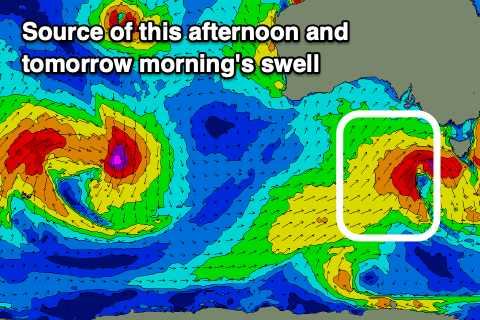
The source of these swells will be a broad low forming north-east of the Heard Island region today, with the catalyst being Severe Tropical Cyclone Vince drifting south into the westerly storm track.
The structure and intensity of the low have changed and not for the better, with most of the swell being aimed more north, towards Indonesia and with less size.

As the low tracks east-southeast along the polar shelf on the weekend, a better aligned fetch of SW gales should produce a more noticeable SW groundswell that’s due later Tuesday, peaking Wednesday morning.
The Surf Coast should see 3-4ft surf from this source with 6ft sets to the east but with those onshore winds, easing Thursday as S’ly winds persist.
Cleaner conditions are due on the beaches from Friday and more so Saturday next week along with some fun levels of mid-period swell. More on this Monday. Have a great weekend!


Comments
Anyone else have quick link things on their phone to BoM sites and found they aren’t working anymore? Something about https?
Gday Nic - yeah it started yesterday on my phone - I've got multiple quick links that aren't working. I'm hoping its temporary as I can't be bothered updating my links - it does say "does not currently support connections via https"
Yeah having the same issue, really annoying.
The bom app is working for me nb, but the website on my phone isn’t
Yeah me too NB.
Have all but given up checking the CS buoy. It’s driving me nuts.
In url, replace anything before bom.gov.au with “https://reg.”
Rebookmarking the following has worked for me:
https://reg.bom.gov.au/products/IDT65014.shtml
Thanks. That did work. Cheers for the tip good sir!!
same on Fake Taxi.
Yeah the links haven’t been working on my iPad for a week or more, same on my iMac.
Heard of this, I think changing the URL to HTTP: may help.
Yes, it's the https part that causes a problem. It has been occurring intermittently for months for me on android.
I find if you click on the link, exit the website then click again, it seems to work fine
Was there some early longer period swell this arvo? Was definitely some stronger sets than I thought would be there.
Potentially inbound little nuggety swell producing low next weekend.
Can't beat a good punchy little nugget SR, they don't need to big as long as they are punching and nugging
haha spot on @ruckus! Nugs!