Indonesia/Maldives forecast Feb 25

Indian Ocean Basin analysis by Craig Brokensha (issued Tuesday 25th February)
This week through next (Feb 26 - Mar 7)
A very inconsistent but noticeable increase in long-range SW groundswell is due later tomorrow, though peaking Thursday across the region, generated by a strong low that fired up in our far swell window, to the south-east of South Africa last week.
It’ll be inconsistent but worth the wait before the swell eases Friday.
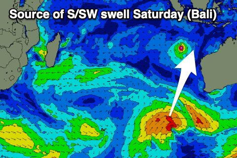
Later Friday but more so Saturday, a small pulse of mid-period S/SW swell is due across eastern Indonesia, generated by a weak but healthy low projecting towards Western Australia yesterday.
This swell will ease into Sunday, though further pulses of small, mid-period S/SW swell are due into the evening, but more so Monday with another pulse for Tuesday afternoon/Wednesday.
These will be generated by weak frontal systems projecting towards Western Australia today and tomorrow, with the size coming in slightly under what is expected Saturday across the magnets.
Otherwise the outlooks remains slow for next week with easing levels of swell from Wednesday.
Local winds look variable over the period though weak E/SE trades are expected into the afternoons and on the weekend and early next week, breaking down through the middle to end of the week.
In the Mentawais, the long-range SW groundswell is due tomorrow, peaking into the afternoon before easing Thursday.
The swells forming off the south-west of Western Australia unfortunately don’t look to offer much size for our region with a small pulse due over the weekend with some secondary swell for early next week.
Winds look variable before possibly swinging more W through next week, more on this Thursday.
----------------------------------------------
Maldives:
Our good S’ly groundswell is in the water today, with it due to ease over the coming days with not much in the way of swell to back it up.
SE trade energy looks small to tiny until we finally see a renewal of energy slowly through next week and more so into the following weekend.
This will be generated by a weak, E/SE trade setup to our south from this weekend, while local westerly winds will strengthen at the same time, feeding into a tropical depression to our south.
At most only a small S/SE swell is likely but more on this Thursday.
Eastern Indonesia:
Moderate sized, inconsistent SW groundswell for later tomorrow, peaking Thursday to 5-6ft across exposed breaks, easing Friday.
Small to moderate sized, mid-period S/SW swell for later Friday, peaking Saturday to 4-5ft across exposed breaks, easing Sunday.
Small to moderate sized, inconsistent S/SW swell for later Sunday, peaking Monday to 3-5ft across exposed breaks.
Secondary, similar sized reinforcing swell for Tuesday, easing Wednesday.
Variable winds ahead of weak sea breezes, with afternoon E/SE trades into the weekend and early next week.
Uluwatu 16-day Forecast Graph/WAMs
Western Indonesia/Mentawais/South Sumatra:
Moderate + sized SW groundswell for tomorrow afternoon and Thursday morning to 5-6ft across exposed breaks.
Small, inconsistent S’ly swell for the weekend to 3-4ft across exposed breaks, generally smaller next week.
Variable winds, possibly tending W’ly through the middle to end of next week.
Mentawai 16-day Forecast Graph/WAMs
Maldives:
Moderate sized S/SW groundswell today to 4-6ft on the southern atolls (smaller Male), easing tomorrow.
Small to tiny levels of background SE swell, increasing a little next week to 2ft to occasionally 3ft across exposed breaks.
Moderate to fresh NE winds tomorrow across central and northern locations, variable to the south, similar Thursday before tending variable NW from Friday.
Freshening W/NW-W winds on the weekend, weakening next week.