Mix of swells building late week, clean and fading Saturday
Eastern Tasmania Surf Forecast by Craig Brokensha (issued Monday 8th January)
Best Days: Friday afternoon northern corners, Saturday morning north facing beaches
Recap
No surf Saturday morning but some N/NE windswell built through the afternoon, peaking Sunday morning with offshore winds and 2ft sets at magnets.
The swell hung in this morning to 2ft across magnets with nice clean conditions again.
Today’s Forecaster Notes are brought to you by Rip Curl
This week and weekend (Jan 9 - 14)
The lingering NE swell seen this morning should of faded through the day and we'll be left with tiny surf into tomorrow and Wednesday morning.
 A small low forming off the coast later tomorrow and Wednesday will bring onshore S/SE tending E winds, but also a small kick in E/SE swell Thursday afternoon. This will be related to a fetch of strong SE winds forming on the south-west flank of the low as it strengthens slightly in the Tasman Sea.
We'll actually see a fetch of SE winds linger off New Zealand's South Island through Thursday before weakening Friday and this will provide small levels of E/SE swell through Friday, easing Saturday.
Open beaches should build to 2ft+ Thursday afternoon, easing slightly from a similar size Friday morning, backing off from 1-2ft Saturday morning.
Winds will unfortunately be onshore from the NE Thursday and strengthening as a strong front approaching from the west squeezes a strong high in the Tasman Sea.
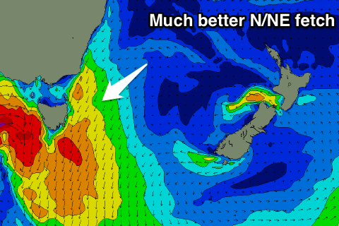
 This will see a great fetch of strengthening N/NE winds developing down our coast, strongest through Friday resulting in a solid increase in N/NE windswell.
North facing beaches are likely to reach 4ft or so but with poor NE tending N/NE winds, easing Saturday as the front moves through with clean fun 2-3ft sets at dawn.
We then may see a secondary front generate a small spike of S'ly swell up our coast later Sunday as it projected a tight fetch of S/SW gales right off the coast, but more on this Wednesday.

