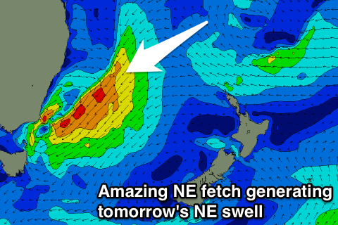
Pumping NE tending E/NE swell to end the week
Eastern Tasmania Surf Forecast by Craig Brokensha (issued Wednesday 6th December)
Best Days: Thursday, Friday, Saturday
Recap
Super fun waves across the coast yesterday morning with an easing S/SE swell before onshore winds moved in, while today was back to 2-3ft with poor winds.
We should be starting to see some new NE swell kicking across the coast from an intense low drifting south through the Tasman Sea, and if not now, definitely later in the day.
Today’s Forecaster Notes are brought to you by Rip Curl
This week and weekend (Dec 7 - 10)
Currently an intense Tasman Low is drifting south through the Tasman Sea, with a great fetch of strong to gale-force NE winds being projected towards us. This is an ideal situation as the swell moves in just as the low keeps dropping south, swinging winds offshore.
 A pumping E/NE swell has been generated across the NSW coast today, and we'll see a late increase in size here ahead of a peak tomorrow morning to a large 5-6ft across open beaches to the north-east direction, easing slowly through the day.
A more pronounced drop in surf is expected from 3ft+ Friday morning, with small 2ft leftovers on Saturday.
Winds tomorrow will be great and offshore from the W/SW through the morning, tending variable ahead of possible sea breezes. Friday morning will be clean as well with a W/SW offshore before sea breezes kick in.
Saturday looks to see all day offshores, and then from here, there's nothing too major on the cards so make the most of the coming swell event. What a period it's been!

