Small NE windswell ahead of larger E/SE groundswell
Eastern Tasmania Surf Forecast by Craig Brokensha (issued Wednesday 4th October)
Best Days: Tomorrow afternoon north-east magnets, Saturday morning, Sunday protected northern corners, Monday, early Tuesday
Recap
Fading tiny south lines yesterday, even smaller into today.
This week and weekend (Oct 5 - 8)
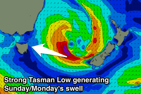
We've got a great and dynamic forecast period ahead as a deepening surface trough moves in from the west, squeezing against a high before pushing into the Tasman and forming into a broad Tasman Low.
As this system moves east tomorrow we'll see a strong fetch of NE winds aimed towards us, kicking up 2ft+ of NE windswell into the afternoon. Winds will swing offshore early/mid-afternoon as the trough pushes across us, so the coast will probably be worth a look.
Into Friday we'll see a fetch of strong S/SW winds aimed up past our coast during the morning, persisting most of the day.
 A moderate to large sized S'ly windswell should build, reaching a messy 5ft or so across south facing spots along with terrible S'ly winds.
Winds will ease along our coast into Saturday as the low starts to take shape, with a great fetch of SE gales being generated through our eastern swell window all day Saturday, weakening into Sunday.
What we should see is a drop in S/SE swell on Saturday from 3ft+ at south magnets (early light W winds), ahead of some new E/SE groundswell possibly showing later in the day but more so Sunday.
Open beaches are expected to build to a solid 4-5ft through the afternoon with the strongest pulse (3-4ft early) but strengthening N/NE winds linked to an approaching front from the west will create less than ideal conditions. Northern corners will be the pick.
A W/NW change is due on Monday cleaning up the E/SE groundswell as it eases quickly from the 4ft range, smaller Tuesday.
Longer term there's nothing too major on the cards, so make the most of the coming swell and check back Friday for one more update on the specifics.

