Wave heights are trending steadily upwards at Cape du Couedic, which is a good sign - as opposed to a J-curve, which often denotes an event of shorter duration.
Primary tabs
/reports/forecaster-notes/south-australia/2022/05/16/very-large-surf-pockets-good-winds
thermalben
Monday, 16 May 2022
/reports/forecaster-notes/south-australia/2022/05/13/classic-autumn-pattern-continue
thermalben
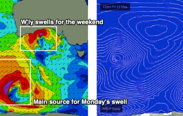
Friday, 13 May 2022
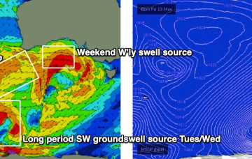
There’s a whole stack of swell on the way too, though initially it’ll be very westerly in direction, originating from a powerful low spinning up immediately south of West Oz that’ll drive a strong front through the Bight.
/reports/forecaster-notes/south-australia/2022/05/11/excellent-surf-ahoy
thermalben
Wednesday, 11 May 2022
The models have slowed Friday’s frontal passage, which has delayed the weekends inbound westerly swell.
/reports/forecaster-notes/south-australia/2022/05/09/strong-winter-pattern-inbound-jetty-jumpers
thermalben
Monday, 9 May 2022
We’ve got a blustery weekend ahead. It’s a classic winter frontal pattern, that may become supercharged thanks to a tropical infeed, courtesy of TC Karim.
/reports/forecaster-notes/south-australia/2022/05/06/fun-weekend-down-south-slowing-the-mid
Craig
Friday, 6 May 2022
Make the most of the waves on the Mid Coast today before the swell fades into the weekend. The South Coast will be fun.
/reports/forecaster-notes/south-australia/2022/05/04/lots-swell-the-mid-though-not-the-cleanest
Craig
Wednesday, 4 May 2022
Plenty of surfable waves on the Mid Coast to end off the week but not the cleanest. Fun surf down South from the weekend into Monday.
/reports/forecaster-notes/south-australia/2022/05/02/large-swell-inbound-tricky-winds
Craig
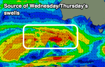
Monday, 2 May 2022
Great surf down South tomorrow ahead of a change and large swell through Wednesday/Thursday, though clean options will be hard to come by.
/reports/forecaster-notes/south-australia/2022/04/29/large-sizey-swells-the-way
Craig
Friday, 29 April 2022
A bit of wind but tons of swell inbound from the west and south west, cleanest on the South Coast over the coming days.

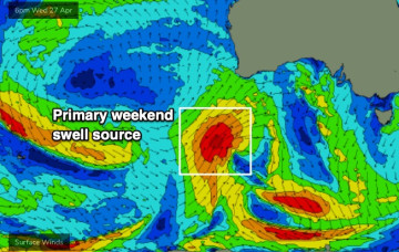
/reports/forecaster-notes/south-australia/2022/04/27/lotsa-swell-lotsa-wind-too
thermalben
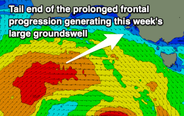
Wednesday, 27 April 2022
We’ve got a week of solid, occasionally windy conditions ahead as more fronts push on to the coast and the Southern Ocean conveyer belt delivers a series of powerful back-to-back groundswells.
/reports/forecaster-notes/south-australia/2022/04/25/fading-surf-great-weekend-ahead
Craig
Monday, 25 April 2022
Small, easing surf for the South Coast over the coming days with a large W/SW groundswell for the weekend with favourable winds.