Lots of swell for the Mid, though not the cleanest
South Australian Surf Forecast by Craig Brokensha (issued Wednesday May 4th)
Best Days: This afternoon Mid Coast, Mid Coast tomorrow morning and Friday morning, South Coast Saturday morning, South Coast Sunday, South Coast Monday
Features of the Forecast (tl;dr)
- Large mix of building mid-period W/SW swell this afternoon with a late pulse of groundswell, peaking tomorrow AM
- Mod-fresh S/SW winds Thu (S/SE-SE early on the Mid, possibly variable for a period early down South)
- Moderate S/SW winds Fri (S/SE-SE early on the Mid, possibly variable for a period early down South) with easing surf
- Smaller, easing Sat with light, local offshore winds and afternoon sea breezes
- Fun, mid-period S/SW swell Sun with NW tending variable winds
- Easing S/SW swell Mon with N/NE winds
- Inconsistent W/SW swell building Wed with NE tending SE winds, easing Thu with NE winds
Recap
Another great day of surf yesterday across the South Coast with clean conditions and 3-4ft sets across the Middleton stretch with an inconsistent SW groundswell, easing through the day as winds strengthened and shifted more NW. The Mid Coast saw wind affected 1-2ft surf all day for the keen.
Today we've got smaller surf down South with an onshore change moving through after dawn, bumpy and 2ft on the Mid Coast with workable cross-onshore winds. We should see the swell spike to a strong 2-3ft during this afternoon with building mid-period W/SW swell energy but this is outlined in more detail below.
This week and next (May 5 - 13)
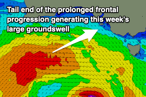
The remnants of the strong storm progression linked to our building swells during today is now moving across the state, bringing this showery and cooler weather. The remnants will form into a broad, multi-centred low, stalling across Victoria and Tasmania, influencing our weather and winds from now through until the weekend.
Coming back to the swell generated by the initial stages of the progression, which started its life late last week, west of the Heard Island region, and this swell was the one seen building across the Margaret River region yesterday.
There's a mix of swells due, with initial mid-period W/SW energy generated by the final stages of the progression due to fill in today, providing the most consistency, while the less consistent but stronger long-period energy should arrive this evening and peak tomorrow morning.
 Building surf to 2-3ft on the Mid Coast is due this afternoon, 4-5ft+ down South across Middleton, with tomorrow seeing surf to 3ft across the Mid Coast (possible rare bigger one) with 5-6ft sets across Middleton. These bigger sets will be inconsistent, with a drop in swell due through the day.
Locally winds should tend lighter S/SE across the Mid Coast in the morning, shifting back S/SW-SW through the day, with the South Coast seeing moderate to fresh S/SW winds, though there might be a period of more variable winds early morning.
Winds look to play out similar through Friday, favouring the Mid Coast over the South Coast but with a drop in swell back from 1-2ft on the Mid Coast, 3-4ft across Middleton.
Moving into the weekend and the swell will continue to bottom out across the Mid Coast with tiny 1ft+ waves left in the gulf Saturday, even smaller Sunday.
 The South Coast looks to ease back to 2-3ft on Saturday, with some small S/SE swell in the mix from a fetch of strong S'ly winds being generated off Tasmania's West Coast, on the backside of the low as it starts to move east.
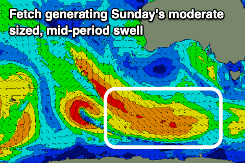
Our new, mid-period S/SW swell for Sunday is on track, generated by a cold front projecting down towards the Polar Shelf, producing a broad fetch of strong to gale-force NW tending W/NW winds.
It should boost the South Coast to a more convincing 3ft across Middleton, easing back Monday from 2-3ft.
As touched on in Wednesday's notes, winds should start to improve for the South Coast Saturday, tending W/NW through the morning and then W/SW-SW into the afternoon, with SE tending SW winds on the Mid Coast.
Sunday should see light NW winds on the South Coast and weak sea breezes, providing fun surf all day.
A slow moving and strong high pushing in from the west will see the surf continuing to ease through Tuesday and bottoming out Wednesday morning as winds hold from the N/NE, favouring those magnets down South.
The next pulses of swell will arrive from the W/SW and be inconsistent, generated by a distant frontal progression developing between Western Australia and Heard Island. The swell looks to come in around 3ft across Middleton with 1-1.5ft sets on the Mid Coast with winds out of the eastern quadrant. More on this in Friday's update though.


Comments
Pumping..
Hi Craig,
interested to know how you forecasted the SE winds on the mid coast this morning? I had been following on willyweather and Meteye for the last few days and they said maybe south at best but mainly SW all night and morning.
Cheers
Using ACCESS-C hi-res forecasts, they're really great and generally bang on for local winds out to 36 hours.
Is it just me that's noticed the BoM have been so far off their game the last 6 months.
Wind, temperature and rain = fail, fail and fail!!!
Today forecasting 15-20kt SW winds - it's been calm all day.
Last week they predicted 12-18hrs out that one of the days we could receive up to 20mm of rain in Adelaide. Not a drop!
In early January the 7 day forecast for Victor Harbour was nothing over 22 degrees. Within 3 days it got to 39.
Absolute joke that mob.
In defence of them, I haven't been keeping a close eye but this troughy weather is much less predictable than normal fronts and highs.
Any slight stalling, movement this way or that effects the local winds and rain totals. Today for the better with those mid-morning to afternoon onshore winds not really materialising.