Smaller end to the week with a strong swell early next week

Western Australian forecast by Craig Brokensha (issued Wednesday February 12th)
Best Days: Friday morning and Saturday morning in the South West, protected spots Monday, Tuesday morning
Features of the Forecast (tl;dr)
- Rapidly easing S/SW swell tomorrow with gusty S/SE winds and stronger sea breezes
- Small new mid-period SW swell Fri/Sat with fresh E/SE morning winds ahead of sea breezes Fri, gusty E/NE Sat ahead of later arriving sea breezes
- Large S/SW groundswell filling in Mon, peaking through the day with strong S/SE-SE winds, mod-fresh S/SE to the north
- Easing swell Tue with strong E/SE winds ahead of sea breezes
Recap
Yesterday was poor across all locations with increasing onshore winds and building levels of windswell, while today our large, mid-period S/SW swell has filled in with protected spots fairing best. Mandurah was a bumpy 2-3ft, with 2ft+ waves in Perth and choppy 8-10ft waves across the South West.
This week and next (Feb 13 - 21)
The current wind and swell are thanks to a strengthening mid-latitude low that fired up to our south-west yesterday, with it since weakening and shifting further east, out of our swell window.
This will result in a steady drop in size through this afternoon and further tomorrow while the direction shifts more south, amplifying the apparent easing trend.
Margs looks to ease from 4ft with tiny 1-1.5ft waves to the north under a less than favourable, gusty S/SE breeze.
Into Friday/Saturday our small pulses of mid-period SW swell are still expected, along with favourable, morning offshore winds.
The source is a weak polar frontal progression that’s currently moving along the polar shelf, with fun 4ft sets due across the South West tomorrow and Saturday, tiny to the north.
A fresh E/SE offshore is due on Friday morning ahead of sea breezes with fresh E/NE winds Saturday, holding longer ahead of sea breezes.
Sunday morning looks smaller and a trough will bring strengthening S/SE tending S/SW winds, while later in the day we may see a hint of new SW groundswell, though the bulk of the size is due on Monday.
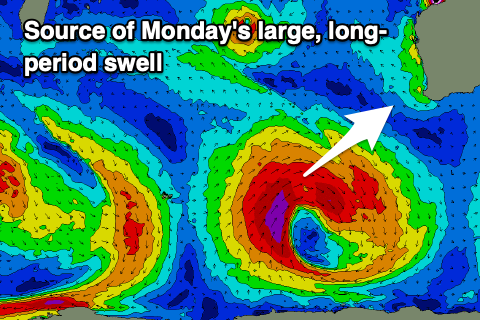
As touched on in the last couple of updates, the source will be a strong low forming to our south-west over the coming days, with the catalyst for its formation being Tropical Cyclone Vince drifting south from the Indian Ocean, being absorbed into the westerly storm track.
This should see a fetch of severe-gale to storm-force W/SW-SW winds generated through our south-western swell window.
The track and fetch alignment aren’t perfect but we should still see a large, long-period S/SW groundswell building to 8-10ft across the South West Monday, 2-3ft Mandurah and 2ft+ Perth during the morning (likely undersized early).
Winds will improve on Monday but remain strong and tricky out of the S/SE-SE in the South West, weaker but still S/SE to the north.
Tuesday will be cleaner but with strong E/SE winds as the groundswell eases back from 4-6ft in the South West, 1-2ft to the north.
Following this there’s nothing too major on the cards though strong offshore winds will create clean conditions with moderate levels of background swell for the South West. More on this Friday.
Comments
Woah.. I’d like to see that! “choppy 8-10ft waves across Perth.” .. ?
1978 Alby Trev ;)
Ha. Fixed.