Large, sizey swells on the way
South Australian Surf Forecast by Craig Brokensha (issued Friday April 29th)
Best Days: Both coasts tomorrow and Sunday, South Coast Monday and Tuesday, Mid Coast for the keen Monday but more so Thursday and Friday morning
Features of the Forecast (tl;dr)
- Large mix of W/SW groundswell and mid-period swell building tomorrow with mod-fresh SW winds, easing and tending W/SW (W/NW early down South)
- Easing mix of swells Sun with light-mod W/NW winds on the Mid, NW tending W/NW down South
- Further drop in swell Mon with N/NW winds (N/NE early on the Mid)
- Late pulse of new SW and W/SW groundswell Mon, peaking Tue AM and easing
- Strengthening N tending NW winds Tue
- Mod-large mix of swells building Wed with fresh W/SW winds, peaking Thu AM with strong S/SW winds (early S on the Mid)
- Easing surf Fri with mod S/SW winds (S/SE early on the Mid)
Recap
Great conditions but tiny surf down South the last two days with a change now approaching, bringing some cloud and rain followed yesterday’s warm weather. The Mid Coast has been tiny to flat and wind affected.
This weekend and next week (Apr 30 - May 6)
 Up, up, up.
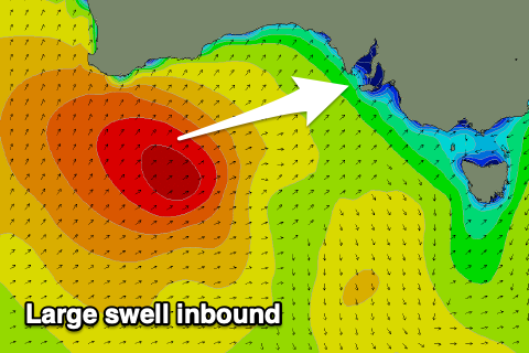
After easing in size steadily this week, we’ve got a very active period of swell due across the state as a progression of mid-latitude and polar systems push in from the west.
Tomorrow we should see a rapid jump in size as a mix of mid-period and stronger W/SW groundswell fill in.
The source of these swells is the same system, with a strong, slow moving polar low firing up initially towards Western Australia, generating severe-gale SW-W/SW winds, weakening while pushing through the Bight and towards us today.
The swell might be a little undersized early but it’ll be well and truly in by midday with strong 3ft surf due on the Mid Coast (possible rare bigger one) with 4-5ft sets developing across Middleton.
A secondary weaker front moving in behind the weakening low looks to spoil winds for the Mid Coast unfortunately with a moderate to fresh SW’ly, easing through the day and tending W/SW. While not the cleanest with the strength of the swell there’ll be plenty of fun options. The South Coast will be best in protected spots with a dawn W/NW breeze, shifting W/SW mid-late morning. Still Middleton should be fun all day with the building swell.
Easing surf is due Sunday with a lighter W/NW breeze due on the Mid Coast, creating OK bumpy waves with 2-3ft sets, while the South Coast looks great with a NW offshore, tending W/NW through the day and easing sets from 4ft across Middleton.
Monday looks smaller with great N/NW winds, best down South with 3ft sets off Middleton and 1-2ft surf across the Mid Coast under a N/NE tending N/NW breeze.
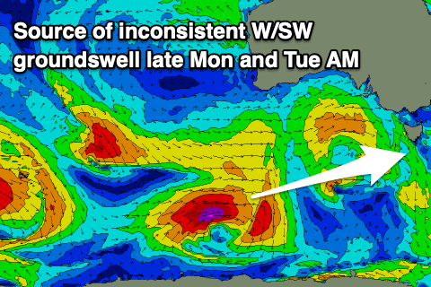
 Later in the afternoon some new, W/SW and SW groundswell are expected, with the first generated by a small low generating a fetch of W/NW gales to the south-west of Western Australia this evening and tomorrow. The low will weaken while passing under the country Sunday. An additional SW groundswell will be generated by a stronger, but tight and small polar low forming south-southwest of Western Australia today.
Both swells look to be a similar size, peaking Tuesday morning to a strong 4ft across Middleton and holding 1-2ft on the Mid Coast, most consistent and more 2ft on the favourable parts of time.
A strong approaching frontal progression will bring strengthening N tending NW winds on Tuesday, adding 2ft of NW windswell to the mix on the Mid Coast while keeping the South Coast clean, biggest early with the swell easing through the day.
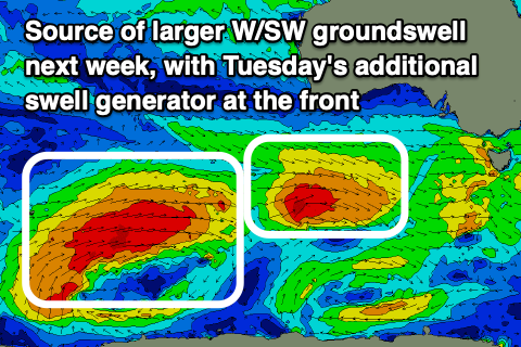
A change is due into Wednesday out of the W/SW, associated with a significant frontal progression that will fire up and under the country, weakening on approach to us, with a moderate to large W/SW groundswell due from this source on Wednesday afternoon and Thursday.
This frontal progression has already started its life as a strong polar low west of the Heard Island region (in our far far swell window), with a fetch of severe-gale to storm-force winds due to weaken as the low moves slowly east.
It’ll continue to generate W/SW gales before breaking down while projecting up and into the Bight Monday evening and Tuesday.
The end result will be a very long-period groundswell mixed in with slightly lower period swell energy, arriving Wednesday afternoon and peaking into the evening/early Thursday.
 Building sets to 4-5ft is due into Wednesday afternoon down South, peaking Thursday to 5-6ft, easing through the day.
The Mid Coast should build to 2-3ft Wednesday afternoon with 3ft surf all Thursday, easing Friday.
Unfortunately it looks like we’ll see S/SW winds into Wednesday afternoon, persisting from the S/SW on Thursday and strong as a high tries to move in behind Wednesday’s front, slowed by a low forming off the southern NSW coast. This will create poor conditions down South with an early S’ly due on the Mid.
Weaker S/SW winds look to persist Friday (S/SE early on the Mid) with easing surf, lingering from the S next weekend as the swell continues to fade. More on all of this Monday though. Have a great weekend!

