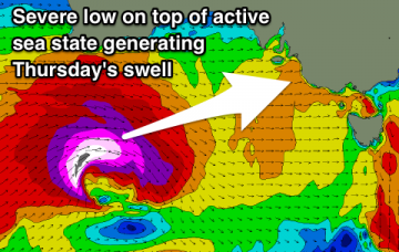
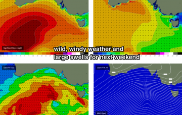
Slowly building surf through tomorrow ahead of an oversized long-period W/SW groundswell filling in Wednesday and secondary large pulse for Thursday.
Primary tabs
/reports/forecaster-notes/south-australia/2018/07/16/back-back-oversized-wsw-groundswells-inbound
Craig
Monday, 16 July 2018
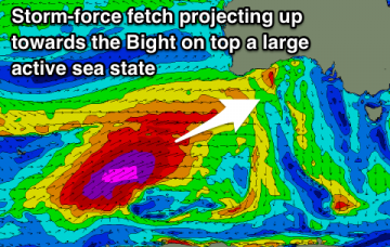
/reports/forecaster-notes/south-australia/2018/07/13/great-weekend-oversized-stormy-swell-through
Craig
Friday, 13 July 2018
A great weekend of waves on the South Coast with a strong new long-period groundswell. Increasing windy and building surf through next week, becoming oversized and stormy before winds improve on the backside of the swell.
/reports/forecaster-notes/south-australia/2018/07/11/all-eyes-are-weekend
Craig
Wednesday, 11 July 2018
Easing surf with slowly improving winds tomorrow, clean Friday but with no decent swell. Much better weekend with good winds and a new swell.
/reports/forecaster-notes/south-australia/2018/07/09/quality-south-coast-tomorrow-and-over-weekend
Craig
Monday, 9 July 2018
Much better conditions tomorrow down South with a good sized easing S/SW swell, smaller Wednesday with a limited window of clean conditions. Average end to the week, much better on the weekend with a new groundswell and great winds.
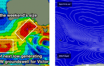
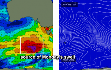
/reports/forecaster-notes/south-australia/2018/07/06/large-and-windy-saturday-improving-sunday-more
thermalben
Friday, 6 July 2018
The low pressure system driving this front is a beauty, and it’s aimed fair and square into Kangaroo Island.
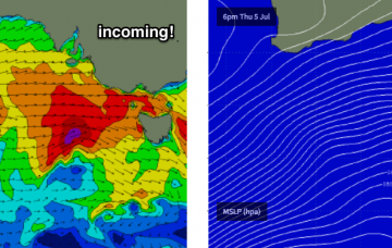
/reports/forecaster-notes/south-australia/2018/07/04/strong-winds-continue-large-swells-inbound
thermalben
Wednesday, 4 July 2018
A much more powerful front, steered by an active node of the Long Wave Trough, will push into our region early Saturday, delivering squally SW winds across the coast and a proper 3-5ft Mid Coast stormy throughout the day with small waves on the metro beaches.
/reports/forecaster-notes/south-australia/2018/07/02/wind-wind-wind-its-gonna-get-windy
thermalben
Monday, 2 July 2018
It’s a great synoptic pattern for swell on the Mid Coast though we’ve obviously got a lot of onshore wind to deal with.
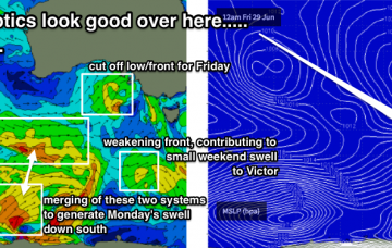
/reports/forecaster-notes/south-australia/2018/06/29/windy-period-ahead-best-suited-south-coast
thermalben
Friday, 29 June 2018
Not an inspiring weekend ahead.
/reports/forecaster-notes/south-australia/2018/06/27/patchy-period-surf-plenty-options-if-yr-keen
thermalben
Wednesday, 27 June 2018
The most promising part of this weather progression is probably the interaction between a polar low and a pre-frontal W/NW flow to its north, positioned S/SW of WA on Thurs/Fri.
/reports/forecaster-notes/south-australia/2018/06/25/small-surf-throughout-week-ok-weekend-waves-both
thermalben
Monday, 25 June 2018
Today's easing swells will continue to abate into Tuesday and will become very small by the afternoon.
