Great weekend, oversized stormy swell through next week, pumping as it eases
South Australian Forecast by Craig Brokensha (issued Friday 13th July)
Best Days: Saturday and Sunday South Coast, keen surfers protected spots later Monday and Tuesday morning on the South Coast, stormy haunts Wednesday morning, Thursday both coasts (experienced surfers only South Coast)
Recap
Poor conditions across both coasts yesterday with an onshore breeze down South, easing into the afternoon creating improving waves, while the Mid Coast was tiny and lumpy/bumpy.
We've got nice clean conditions on offer across both regions today, but only small leftovers, best at Waits and Parsons. A new long-period SW groundswell is due later today across the South Coast so keep an eye on the local surfcams.
Today’s Forecaster Notes are brought to you by Rip Curl
This weekend and next week (Jul 14 - 20)
Want to receive an email when these Forecaster Notes are updated? Then log in here and update your preferences.
Our great weekend of offshore surf for the South Coast is still on track, with a strong and slow moving polar low generating gale to severe-gale W'ly winds through our swell window most of this week.
A long-period SW groundswell has been produced, with a late increase in size on dark more than likely down South, peaking tomorrow morning to a strong 4-5ft off Middleton on the sets.
A slow downwards trend should be seen during the day, smaller and easing from 2-3ft on Sunday morning off Middleton.
Excellent moderate to fresh N tending N/NW winds are due through tomorrow, NW tending N/NW on Sunday creating good waves all weekend.
The Mid Coast is due to hang around 1ft tomorrow on the sets, wind affected from the northerly breezes, while Sunday will see a small new mid-period W/SW swell to 1-2ft, generated by a fetch of strong W/SW winds passing under the WA south coast today.
Conditions will be less than ideal though with those NW-N/NW winds.
We're looking at a low point in swell across the South Coast Monday morning with strengthening NW tending W/NW winds as a vigorous frontal progression starts encroaching from the west.
Now into the afternoon some new inconsistent long-period SW groundswell is due, produced by a distant polar low in the Heard Island region this week, and we should see Middleton building to an inconsistent 2ft to maybe 3ft by dark.
This is just a small note ahead of the activity due into Tuesday and Wednesday though.
 Currently a strong node of the Long Wave Trough is developing west of WA and this will move slowly east through the weekend and early next week.
With this we'll see back to back polar storms directed initially through our far swell window and then medium to close-range swell window.
During today and tomorrow a broad and elongated fetch of severe-gale W/NW winds will swing in from the Heard Island region, tending more W/SW while projecting east-northeast towards the southern WA coast.
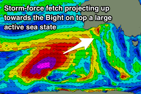
This will produce a large active sea state for a trailing fetch of storm-force W/SW winds to move over, projecting slowly up through our western swell window and through the Bight in a captured fetch like motion.
What will result is an XXL W/SW groundswell for exposed west and south-west facing breaks across the state mixed in with localised windswell as the storm proper moves across us through Tuesday and Wednesday.
On Tuesday we're due to see a mix of building and strengthening swells, with the Mid Coast being mostly stormy and from a NW direction with strong to gale-force NW winds ahead of a gale-force W/SW change mid-late afternoon.
Stormy 2-3ft waves from the NW should swing W/SW into the afternoon and reach 4ft by dark.
The South Coast will see a peak in inconsistent SW groundswell to 3ft+ off Middleton, with some larger mid-period W/SW swell building into the afternoon. Sets may push over 4ft later but with gale-force NW tending W'ly winds, creating very average conditions.
Come Wednesday the long-period groundswell proper is due to fill in, building through the day and peaking later in the day to 8ft+ off Middleton with larger sets at deepwater reefs and monstrous at Waits and Parsons.
The Mid Coast looks to come in at a stormy though improving 4-5ft+, with fresh to strong but quickly moderating W/SW winds. There's an outside chance for early W'ly winds around Victor at dawn, but we'll have to confirm this on Monday.
Thursday looks like the pick of the week, with another strong front approaching from the west bringing gusty N/NW tending NW winds along with large easing 8ft+ surf across most exposed breaks down South.
The Mid Coast may see early N/NE breezes and easing 3-4ft sets. We'll go over all of this again on Monday though with more confidence on the timing, sizes and local winds. Have a great weekend!

