Indonesia/Maldives forecast Feb 13

Indian Ocean Basin analysis by Craig Brokensha (issued Thursday 13th February)
This week through next (Feb 14 - 21)
Downgrade.
Unfortunately the only real significant swell due through the period, mid-late next week has been downgraded.
The source, which will be Severe Tropical Cyclone Vince drifting south from the Indian Ocean today, into the westerly storm track, is still forecast as such, but the intensity of the developing low has been downgraded.
We’re only due to see a short-lived fetch of severe-gale S/SW winds generated through our swell window as the low moves east.
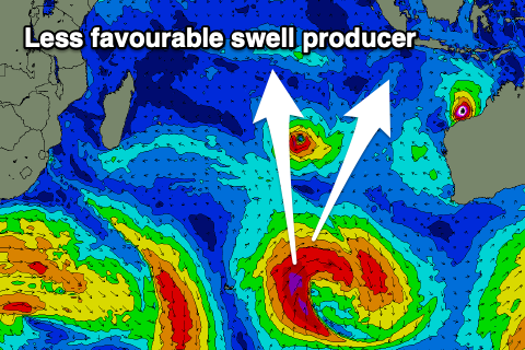
This will limit the swell size to the moderate + range, with it due to arrive early Wednesday, building to peak into the late afternoon/Thursday morning before easing.
Coming back to the next few days though, and a mix of background, inconsistent SW groundswell and some more local mid-period swell is due tomorrow as winds relax and become more favourable.
A fresh spike of S’ly swell is due later tomorrow but more so Saturday thanks to tropical developments of Western Australia, fading Sunday.
In the Mentawais, the current mid-period SW swell and some background SW groundswell should start to ease into the weekend, with the S’ly groundswell for mid-next week not expected to offer much over 4-5ft on the magnets. It's still worth penciling in though.
Winds look favourable and mostly variable, tending more NW at times through next week across southern locations.
----------------------------------------------
Maldives:
A fun mix of background S/SW swell and SE trade-swell the last couple of days will be superseded by some better mid-period SE swell later tomorrow but more so over the weekend.
This has been generated by slow moving Tropical Cyclone Taliah, with the direction expected to tweak more S/SE as the size fades from Sunday afternoon.
Smaller surf is due into early next week, but the low forming from the remnants of Severe Tropical Cyclone Vince being absorbed into the westerly storm track, should produce a good pulse of S/SE groundswell that’s due mid-week, easing into Thursday/Friday.
Otherwise the healthy frontal progression below South Africa is still on track and should generate some fun sized groundswell for later Thursday afternoon and Friday morning on the southern atolls.
Eastern Indonesia:
Mix of swells tomorrow, with a background groundswell coming in strongest to 4ft+.
Moderate sized, mid-period S’ly swell for later tomorrow, easing Saturday from 5ft.
Moderate + S/SW groundswell building next Wednesday afternoon to 4-6ft across exposed breaks, easing from a similar size Thursday morning
Lighter winds develop during this period with variable offshore winds and variable sea breezes.
Uluwatu 16-day Forecast Graph/WAMs
Western Indonesia/Mentawais/South Sumatra:
Small, inconsistent SW groundswell Friday to 3-5ft.
Moderate sized, mid-period S’ly swell building Saturday to 4ft, easing Sunday.
Moderate sized S/SW groundswell for later next Wednesday and Thursday to 4-5ft+ across exposed breaks.
Variable winds, possibly tending NW at times across southern locations next week.
Mentawai 16-day Forecast Graph/WAMs
Maldives:
Inconsistent SE tending S/SE swell strengthening into the weekend to 4ft+ across central locations, easing early next week.
Moderate sized, inconsistent S/SE groundswell next Wednesday to 4-5ft across exposed breaks, easing Thursday.
Small to moderate sized, inconsistent S/SW groundswell for next Thursday afternoon and Friday to 4ft on the southern atolls.
Moderate N/NE-NE winds through the weekend across northern and central locations, easing next week. Lighter N winds to the south.
Comments
Latest notes are live.
Thanks Craig , winds finally backed off , had a fun grovel today , couple of sets surprised me , looking at that window on Saturday lunch time for swell , tide & wind . Cheers