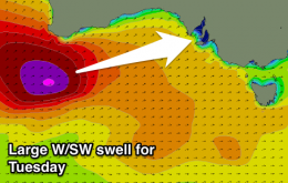
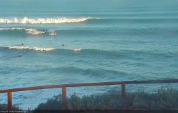
Smaller W/SW swells over the weekend with variable winds tomorrow morning and a gusty offshore ahead of a W/SW change Sunday. Stormy average waves Monday, improving Tuesday and great Wednesday with a strong new swell.
Primary tabs
/reports/forecaster-notes/south-australia/2016/06/03/ok-weekend-down-south-better-tuesday-next-week
Craig
Friday, 3 June 2016
/reports/forecaster-notes/south-australia/2016/06/01/good-clean-swell-tomorrow-easing-weekend
Craig
Wednesday, 1 June 2016
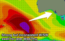
Strong but inconsistent new W/SW groundswell for tomorrow, easing slowly Friday with some smaller reinforcing pulses for the weekend.
/reports/forecaster-notes/south-australia/2016/05/30/strong-wsw-swell-mid-week
Craig
Monday, 30 May 2016
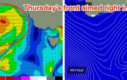
New inconsistent W/SW swell for tomorrow with favourable winds, bottoming out Wednesday morning ahead of a strong kick in new swell later in the day, peaking Thursday morning.
/reports/forecaster-notes/south-australia/2016/05/27/fun-waves-most-days-across-both-south-oz-coasts
thermalben
Friday, 27 May 2016
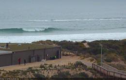
Sunday looks like a great day for the South Coast with winds veering to the NE and freshening - this will iron out any residual lumpiness from Saturday’s early onshores.

/reports/forecaster-notes/south-australia/2016/05/25/wide-range-surf-and-conditions-south-oz
thermalben
Wednesday, 25 May 2016
Thursday is still on target for some good waves across both coasts.
/reports/forecaster-notes/south-australia/2016/05/23/clean-victor-options-first-then-decent-swell-mid
thermalben
Monday, 23 May 2016
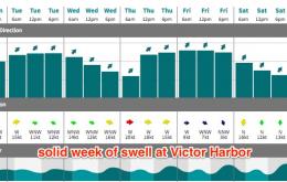
Tuesday and Wednesday are looking excellent for the Victor stretch.
/reports/forecaster-notes/south-australia/2016/05/20/windy-weekend-ahead-small-windows-opportunity
thermalben
Friday, 20 May 2016
Today’s swell is expected to drop steadily from tonight onwards, and northerly winds will freshen throughout Saturday as a dominant high pressure system moves slowly across the region.
/reports/forecaster-notes/south-australia/2016/05/18/plenty-swell-still-radar-south-oz
thermalben
Wednesday, 18 May 2016
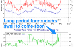
We’ve got more swell on the way.

/reports/forecaster-notes/south-australia/2016/05/16/great-waves-ahead-south-oz-windows-good-winds
thermalben
Monday, 16 May 2016
Right now we’ve got a cold front steam-rolling through the Bight; a change is expected locally this evening but it’ll clear quickly to the east, leaving mainly moderate W’ly tending light NW winds in its wake.
/reports/forecaster-notes/south-australia/2016/05/13/clean-easing-surf-over-weekend-new-swell-monday
Craig
Friday, 13 May 2016
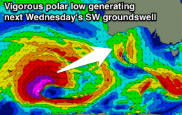
Slow easing SW swell over the weekend with all day offshores tomorrow, and then a weak change through Sunday afternoon. New long-range W/SW groundswell Monday morning with a much larger W/SW swell for Tuesday.