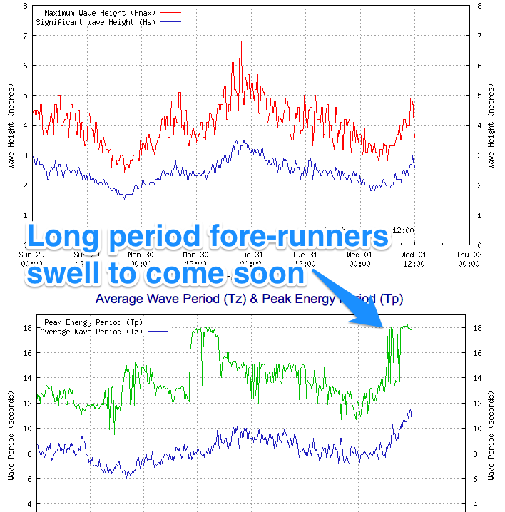
Good clean swell tomorrow, easing off into the weekend
South Australian Forecast by Craig Brokensha (issued Wednesday 1st June)
Best Days: Thursday and Friday both coasts, Saturday down South
Recap
Small waves across the South Coast the last couple of days, best suited to Waits and Parsons, while the Mid Coast offered workable 1-2ft waves yesterday with a N/NE wind, easing back to 1-1.5ft this morning.
Into this afternoon though a strong and powerful W/SW groundswell is due to fill in, kicking the Mid back to 2ft and 3-4ft at Middleton. The Cape du Couedic wave buoy registered 18s forerunners this morning with the swell proper due later this afternoon.
This week and weekend (Jun 2 - 5)
 This afternoon's building groundswell is due to peak tomorrow morning across both coasts with inconsistent but good 2ft to occasionally 3ft sets on the Mid and 4-5ft waves along the Middleton stretch, much larger at Waits and Parsons.
Conditions will be best through the morning down South with a N/NE wind, swinging more NE through the day, while the Mid Coast should be good most of the day under a NE tending E/NE breeze.
A drop in swell is due from Thursday afternoon, further Friday with easing 2ft sets on the Mid under a NE tending E/NE wind and then SE sea breezes.
Smaller surf is expected over the weekend, but two small reinforcing W/SW pulses are due, the first for Saturday and the second for Sunday.
Both will be inconsistent and not offer any major size, generated in the southern Indian Ocean, with Sunday morning's being the strongest.
The Mid should continue around 1-1.5ft Saturday with 1-2ft sets Sunday but also with a stormy building swell to 2-3ft later in the day from a strong mid-latitude front pushing in from the west.
The South Coast is expected to hang around 2-3ft along the Middleton stretch with 4ft+ sets at Waits and Parsons, a touch stronger Sunday morning.
Conditions Saturday are looking good most of Saturday with a variable breeze (likely offshore through the morning) and then Sunday will see strong N/NW winds ahead of a strong W/SW change mid-late morning.
Next week onwards (Jun 6 onwards)
Sunday's strong front and change will continue to push right up and into us Monday kicking up 3ft+ of stormy swell for the morning but with S/SW winds.
The South Coast will also see average stormy waves with a touch more size.
Of greater importance is a moderate to large new W/SW groundswell due across the state Wednesday. This will be produced by a very strong and long lived polar frontal progression firing up in the Southern Ocean south-west of WA, but more on this Friday.

