OK weekend down South, better from Tuesday next week
South Australian Forecast by Craig Brokensha (issued Friday 3rd June)
Best Days: Beginners Mid Coast tomorrow, South Coast through the morning and Sunday morning, South Coast Tuesday and Wednesday
Recap
Great waves across the Mid Coast yesterday with 2-3ft sets and offshore winds all day. The South Coast also saw good conditions with strong sets between 3-5ft along the Middleton stretch and around town before sea breezes kicked in.
Today the swell was easing from a glassy and clean 3ft down South and 1-2ft on the Mid.
This weekend and next week (Jun 4 - 10)
Smaller surf is due over the weekend, with some background W/SW groundswell pulses due both tomorrow and Sunday morning.
The Mid is due to hover around 1-1.5ft tomorrow with variable tending S/SW winds while Middleton should see 2ft to occasionally 3ft waves along the Middleton stretch and 4ft+ waves at Waits and Parsons. Conditions will also be best through the morning with a variable breeze.
Sunday looks to offer a bit stronger sets to 2-3ft at Middleton and 4-5ft at Waits and Parsons with 1-2ft waves on the Mid although with gusty N/NW winds ahead of an afternoon W/SW change.
This change is likely to kick up a late stormy swell on the Mid, but only to 2ft or so at this stage, becoming much stronger into Monday as a fetch of W/SW gales are projected into the state.
2-3ft of messy short-period swell is due to be seen Monday morning on the Mid, fading quickly with easing SW winds. The South Coast will be average and weak with similar weak amounts of swell to 3ft+ or so across the Middleton stretch.
Cleaner conditions are due into Tuesday as a new small SW swell fills in under W/NW tending N'ly winds.
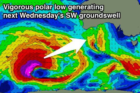
 Of much greater importance is the strong long-period and inconsistent SW groundswell due Wednesday. A vigorous polar low due is due to form in the Heard Island region through this afternoon, projecting a broad and prolonged fetch of severe-gale to storm-force SW winds towards Western Australia.
A large long-period SW groundswell will be generated with the fore-runners due to arrive Tuesday with the swell peaking Wednesday morning to an inconsistent 4-5ft along the Middleton stretch and 6ft+ at Waits and Parsons. The Mid looks to come in around 2ft or so but strengthening NW winds will favour protected locations down South. More on this Monday, have a great weekend!

