Strong W/SW swell mid-week
South Australian Forecast by Craig Brokensha (issued Monday 30th May)
Best Days: South Coast tomorrow (Mid afternoon), both coasts later Wednesday, Thursday and Friday, Mid Coast Saturday
Recap
Rapidly improving conditions across the South Coast Saturday with a fresh morning offshore tending variable by mid-morning with some decent swell about. Sunday was clean all day with fun easing levels of swell.
A close-range W'ly swell provided great waves across the Mid Coast Saturday with clean 2ft to occasionally 3ft sets most of the day, easing back to the 1-2ft range yesterday.
Today the surf was back to a tiny and wind affected 1ft on the Mid, with cleaner but small leftovers down South.
This week (May 31 – Jun 3)
As Ben mentioned a couple of weeks ago when he took over, it's a little tricky coming in cold to a forecast, but we'll stick with Ben's numbers for tomorrow with the arrival of a new inconsistent W/SW groundswell due this evening. It's actually just hit the Cape du Couedic wave buoy in the form of peak periods to 18s, but the increase in size is short-range W'ly swell from a weakening low in the Bight.
This short-range W'ly swell and W/SW groundswell are due to peak tomorrow across both coasts with the Mid seeing 1-2ft sets, while the South Coast will be the pick with infrequent 2ft sets along the Middleton stretch and better 3ft to occasionally 4ft sets at Waits and Parsons under a fresh and gusty but easing N/NE offshore.
Wednesday morning will be clean again but small as we fall in between swells. Waits is the best option, but later in the day a strong new W/SW groundswell should fill in across the region, peaking Thursday.
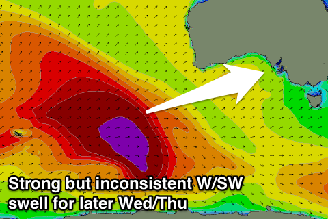
 A significant and broad polar frontal progression developed in the southern Indian Ocean with satellite observations confirming a fetch of storm-force (50-55kt) W/SW winds being aimed through our western swell window.
This progression is now weakening and dipping south-east to the south-west of WA, leaving the large long-period but inconsistent W/SW groundswell to travel towards us.
The swell is due to arrive through Wednesday afternoon and build to 2ft late in the day on the Mid Coast while the South Coast should see 3-4ft sets at Middleton and larger waves at Waits and Parsons.
Winds will be great with a weakening pressure gradient over the state resulting in moderate to fresh but easing N/NE winds, likely variable into the mid-late afternoon.

A peak in size is due Thursday morning to a strong but inconsistent 4-5ft along the Middleton stretch down South with 2ft to occasionally 3ft sets on the Mid as N/NE offshores tend E/NE through the afternoon.
Easing surf into Thursday afternoon will continue Friday with a less favourable E/NE'ly ahead of SE sea breezes.
This weekend onwards (Jun 4 onwards)
Into Saturday some small reinforcing W/SW groundswell is due from a less than favourably aligned pre-frontal W/NW fetch off WA, and this should keep the Mid ticking over at an inconsistent 1-2ft. Middleton looks to hold around 2ft+ with 4ft sets at Waits and Parsons. The only issue are the local winds with E/SE breezes causing issues, possibly swinging more W/NW Sunday with a secondary slightly stronger pulse of long-range W/SW groundswell. More on this Wednesday though.

