Clean easing surf over the weekend, new swell for Monday ahead of a larger pulse Tuesday
South Australian Forecast by Craig Brokensha (issued Friday 13th May)
Best Days: South Coast Saturday, Sunday morning, Monday, Wednesday, Mid Coast for keen surfers Monday through Wednesday
Recap
Great waves the last few days across the South Coast with lots of swell between 3-5ft across the Middleton and Victor stretch with favourable winds. The Mid Coast was a bumpy 2ft yesterday, while today we're back to smaller 1-2ft sets with cleaner conditions.
This weekend and next week (May 14 - 20)
South Coast: Today's swell is due to ease off into this afternoon, slowed through tomorrow by a reinforcing pulse of SW energy generated by a fetch of W'ly gales moving through our swell window yesterday.
Middleton should be around 3-4ft with larger 5ft+ sets at Waits and Parsons, easing through the day and further from 3ft and 4ft+ respectively Sunday morning.
Conditions will be great tomorrow with a moderate to fresh N/NW'ly persisting all day, while Sunday will see W/NW winds ahead of a shallow SW change around midday/early afternoon.
Later in the day we may see the fore-runners of a long-period W/SW groundswell due to peak Monday, generated by a strong and pro-longed polar frontal progression through the southern Indian Ocean.
This swell is expected to peak Monday morning to a strong but inconsistent 3-4ft+ across Middleton with 5-6ft sets at Waits and Parsons, easing through the day. Moderate to fresh N//NW tending W/NW winds will keep conditions clean most of the day ahead of a mid-late afternoon W/SW change.
Now, this change will be linked to a very strong and powerful but weakening mid-latitude low moving in from Western Australia.
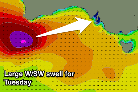
Over the weekend, this low is forecast to generate a fetch of severe-gale to storm-force W/SW winds directly through our western swell window, ideally for the Mid, producing a large powerful long-period W/SW groundswell for Tuesday.
 The low will weaken while moving through the Bight, but continue to generate a fetch of gale to severe-gale W/SW winds while passing under us Monday, producing solid amounts of short-range W/SW swell for Tuesday morning ahead of the groundswell proper through the day.
Middleton should see large 4-6ft sets with 8ft waves off Waits and Parsons, easing back quickly through Wednesday. Moderate to fresh W'ly winds are due, likely W/NW through the morning and then W/SW into the afternoon Tuesday, with a NW offshore Wednesday.
Mid Coast: Our recent run of waves will continue to ease through tomorrow, with fading 1-1.5ft waves tomorrow and then 1ft+ sets Sunday.
The long-range W/SW groundswell for later Sunday may kick to 1-1.5ft late, but Monday will see a peak to a good 2ft+ but with average conditions.
Of greater importance is the W/SW groundswell for Tuesday with sets due to reach a solid 3-4ft on the favourable parts of the tide. Conditions will be average though with that moderate to fresh W'ly.
A drop in size from 2-3ft is due Wednesday as NW winds continue to create less than ideal conditions. We'll confirm this on Monday though. Have a great weekend!


Comments
Nice lines at Middleton this AM.