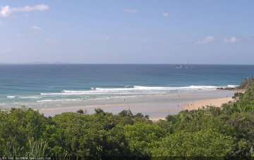
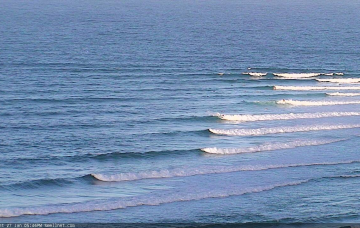
You know what? Take the next three days off. It ain’t really worth it. Especially given the incredible couple of weeks we’ve had. But.. there are waves ahead.
Primary tabs
/reports/forecaster-notes/south-east-queensland-northern-new-south-wales/2021/02/08/flag-the-short
thermalben
Monday, 8 February 2021

/reports/forecaster-notes/south-east-queensland-northern-new-south-wales/2021/02/05/dont-stop-till
thermalben
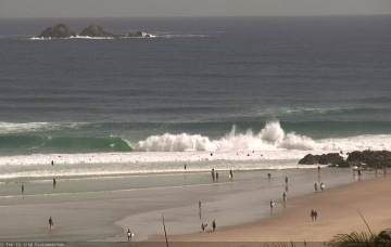
Friday, 5 February 2021
Incredibly, we’ve got more of the same for the weekend.
/reports/forecaster-notes/south-east-queensland-northern-new-south-wales/2021/02/03/rinse-and-repeat
thermalben
Wednesday, 3 February 2021
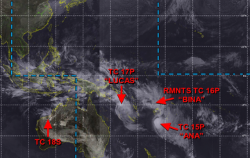
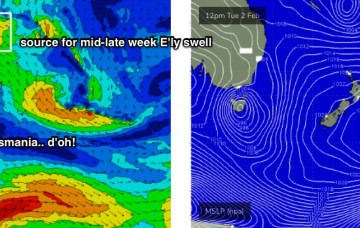
TC Lucas will remain slow moving south of New Caledonia for a few days. Current model guidance suggests a reintensification overnight Thursday into Friday morning (see below), aimed perfectly within our swell window.
/reports/forecaster-notes/south-east-queensland-northern-new-south-wales/2021/02/01/building-ely
thermalben
Monday, 1 February 2021
As discussed over the last week, we’ve got an active MJO phase across the region, and a strong high pressure ridge across New Zealand is cradling a conveyor belt of tropical lows, including one remnant and two existing tropical cyclones (TC Bina, TC Lucas, TC Ana - see recent chart from JTWC below).
/reports/forecaster-notes/south-east-queensland-northern-new-south-wales/2021/01/29/lotsa-east-swell
thermalben
Friday, 29 January 2021
We’ve got a warning out for a developing tropical cyclone north-east of Vanuatu, which will probably occur within the next 24 hours. This is contained with an active monsoon trough, which currently stretches from Indonesia, across Northern Australia into the western Pacific and then across to the South Pacific, somewhere south of the Cook Islands and about at SE Qld latitudes. More in the Forecaster Notes.
/reports/forecaster-notes/south-east-queensland-northern-new-south-wales/2021/01/27/no-end-the
thermalben
Wednesday, 27 January 2021
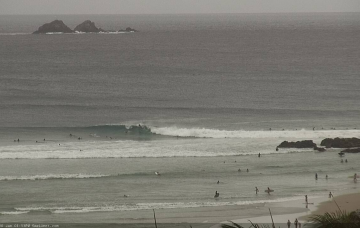
By and large, swell prospects for the next few days look much the same as the last few. However, conditions will change across the region, ultimately switching favouritism from the north to the south. More in the Forecaster Notes.
/reports/forecaster-notes/south-east-queensland-northern-new-south-wales/2021/01/25/endless-easterly
thermalben
Monday, 25 January 2021
It's a pretty typical summer pattern, to be honest. Very bluebottle friendly, mind. More in the Forecaster Notes.
/reports/forecaster-notes/south-east-queensland-northern-new-south-wales/2021/01/22/easing-surf-still
thermalben
Friday, 22 January 2021
Long term maintains a whole stack of near-stationary swell sources in the Northern Tasman Sea, lower Coral Sea and South Pacific, so it looks like we’ll be back to the easterly swell machine for quite a few weeks. More in the Forecaster Notes.

/reports/forecaster-notes/south-east-queensland-northern-new-south-wales/2021/01/20/strong-sse-swells
thermalben
Wednesday, 20 January 2021
One of the difficulties in preparing a forecast at a time like this, is trying to seperate the events of the last 24 hours from what’s expected over the coming days. More in the Forecaster Notes.
/reports/forecaster-notes/south-east-queensland-northern-new-south-wales/2021/01/18/large-sustained
thermalben
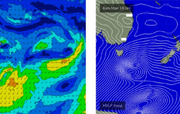
Monday, 18 January 2021
All eyes are to the south. More in the Forecaster Notes.