Long term maintains a whole stack of near-stationary swell sources in the Northern Tasman Sea, lower Coral Sea and South Pacific, so it looks like we’ll be back to the easterly swell machine for quite a few weeks. More in the Forecaster Notes.
Primary tabs
/reports/forecaster-notes/south-east-queensland-northern-new-south-wales/2021/01/22/easing-surf-still
thermalben
Friday, 22 January 2021

/reports/forecaster-notes/south-east-queensland-northern-new-south-wales/2021/01/20/strong-sse-swells
thermalben
Wednesday, 20 January 2021
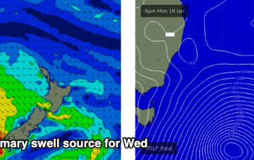
One of the difficulties in preparing a forecast at a time like this, is trying to seperate the events of the last 24 hours from what’s expected over the coming days. More in the Forecaster Notes.
/reports/forecaster-notes/south-east-queensland-northern-new-south-wales/2021/01/18/large-sustained
thermalben
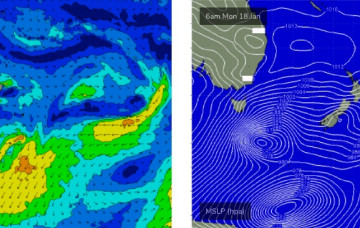
Monday, 18 January 2021
All eyes are to the south. More in the Forecaster Notes.
/reports/forecaster-notes/south-east-queensland-northern-new-south-wales/2021/01/15/and-it-came-the
thermalben
Friday, 15 January 2021
The long running easterly swell machine that’s provided an extended period of useful trade swells is finally drawing to a close. But there's a stack of south swlel on the way. More in the Forecaster Notes.
/reports/forecaster-notes/south-east-queensland-northern-new-south-wales/2021/01/13/dynamic-forecast
thermalben
Wednesday, 13 January 2021
We're coming to the end of a long E'ly swell cycle, as a strong S'ly swell cycle starts to take shape. More in the Forecaster Notes.

/reports/forecaster-notes/south-east-queensland-northern-new-south-wales/2021/01/11/reasonable-week
thermalben
Monday, 11 January 2021
Looks like a fun week of useful trade swell across most coasts. And there's a whole stack of south swell for next week. More in the Forecaster Notes.
/reports/forecaster-notes/south-east-queensland-northern-new-south-wales/2021/01/08/more-the-same
thermalben
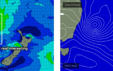
Friday, 8 January 2021
There’s plenty of surf due next week but no major size. More in the Forecaster Notes.
/reports/forecaster-notes/south-east-queensland-northern-new-south-wales/2021/01/06/plenty-surf
thermalben
Wednesday, 6 January 2021
Gusty S/SE winds will dominate the rest of the week, though it’ll actually originate from a second change currently pushing into Southern NSW (this afternoon’s change was associated with a local trough).
/reports/forecaster-notes/south-east-queensland-northern-new-south-wales/2021/01/04/peaky-options
thermalben
Monday, 4 January 2021
First up: swell. There won’t be any shortage of it this week, thanks to a broad ridge north of New Zealand. More in the Forecaster Notes.
/reports/forecaster-notes/south-east-queensland-northern-new-south-wales/2021/01/01/typical-summer
thermalben
Friday, 1 January 2021
We’ve got building E’ly swells for SE Qld and Far Northern NSW, originating primarily from a broad, complex series of surface troughs across the lower Coral Sea. More in the Forecaster Notes.