/reports/forecaster-notes/south-east-queensland-northern-new-south-wales/2015/04/02/more-punchy-trade
thermalben
Thursday, 2 April 2015
On Easter Friday, the weakening trades across our swell window will also occur across the coast, which is great news as it means a much improved overall outlook for SE Qld surf conditions under light variable tending onshore winds.
/reports/forecaster-notes/south-east-queensland-northern-new-south-wales/2015/03/31/fun-trade-swell
thermalben
Tuesday, 31 March 2015
Finally, we’ve got some good waves ahead for SE Qld.
/reports/forecaster-notes/south-east-queensland-northern-new-south-wales/2015/03/27/patchy-weekend
thermalben
Friday, 27 March 2015
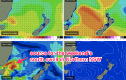
It’s not a great weekend of waves ahead - especially SE Qld - but there will be surfable options if you’ve got access to a south facing beach between Byron Bay and Seal Rocks.
/reports/forecaster-notes/south-east-queensland-northern-new-south-wales/2015/03/25/small-east-swell
thermalben
Wednesday, 25 March 2015
This small, inconsistent E’ly swell from TC Rueben will dominate the next few days.
/reports/forecaster-notes/south-east-queensland-northern-new-south-wales/2015/03/23/thursday-and
thermalben
Monday, 23 March 2015
Overnight on Wednesday, the leading edge of a small easterly swell is expected to push through, generated by TC Reuben yesterday and today, way out south-east of Fiji.
/reports/forecaster-notes/south-east-queensland-northern-new-south-wales/2015/03/20/small-and-mixed
thermalben
Friday, 20 March 2015
We’re looking at small waves through the entire weekend, with variable conditions across the region.
/reports/forecaster-notes/south-east-queensland-northern-new-south-wales/2015/03/18/poor-short-term
thermalben
Wednesday, 18 March 2015
We’re finally drawing to a close some six days of thoroughly decent easterly swell.
/reports/forecaster-notes/south-east-queensland-northern-new-south-wales/2015/03/16/great-waves
thermalben
Monday, 16 March 2015
I also think that we’re probably close to the peak of the upwards phase of this swell event across SE Qld and Northern NSW.
/reports/forecaster-notes/south-east-queensland-northern-new-south-wales/2015/03/13/trade-swell
thermalben
Friday, 13 March 2015
We’re essentially looking at a combination of trade swells from two sources.
/reports/forecaster-notes/south-east-queensland-northern-new-south-wales/2015/03/11/building-trade
thermalben
Wednesday, 11 March 2015
The current synoptic pattern lends itself to two main characteristics - a slow increase in size through into the weekend, and a focus of the largest waves toward northern locations.

