Late Wednesday will see the first of three new swells making landfall across the Mid North Coast, and they're expected to provide plenty of surf into Thursday - though local conditions are still a concern.
Primary tabs
/reports/forecaster-notes/south-east-queensland-northern-new-south-wales/2018/06/04/tricky-winds-week
thermalben
Monday, 4 June 2018
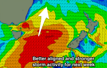
/reports/forecaster-notes/south-east-queensland-northern-new-south-wales/2018/06/01/large-weekend-sly
thermalben
Friday, 1 June 2018
The general swell trend should remain very large from the south throughout Saturday.

/reports/forecaster-notes/south-east-queensland-northern-new-south-wales/2018/05/30/sustained-period
thermalben
Wednesday, 30 May 2018
A Tasman Low will form overnight in the central Tasman Sea, and a series of secondary lows and surface fronts wrapping around its western flank will maintain gale force S’ly winds parallel to the NSW Coast for several days.
/reports/forecaster-notes/south-east-queensland-northern-new-south-wales/2018/05/28/days-and-days
thermalben
Monday, 28 May 2018
We’ve got a couple of quiet days lining up ahead of a prolonged onslaught of southerly wind and southerly swell.

/reports/forecaster-notes/south-east-queensland-northern-new-south-wales/2018/05/25/strong-though
thermalben
Friday, 25 May 2018
It’s a mixed bag this weekend.

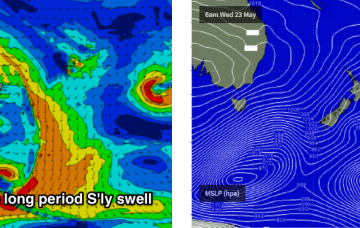
/reports/forecaster-notes/south-east-queensland-northern-new-south-wales/2018/05/23/large-long-period
thermalben
Wednesday, 23 May 2018
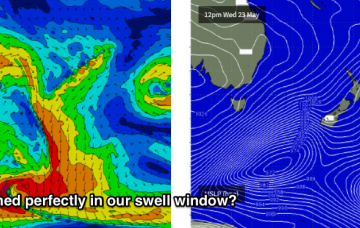
Again, there’ll be an enormous variation in size right across the coast, thanks to the southerly direction.
/reports/forecaster-notes/south-east-queensland-northern-new-south-wales/2018/05/21/back-back-large
thermalben
Monday, 21 May 2018
By and large, because of this synoptic pattern, these Forecaster Notes are almost the same for Southern NSW as they are for Northern NSW, except for a few key points.
/reports/forecaster-notes/south-east-queensland-northern-new-south-wales/2018/05/18/south-south-and
Craig
Friday, 18 May 2018
Plenty of south swell to come over the coming period, larger mid-late next week.
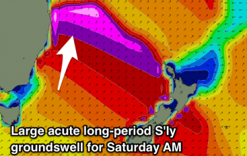
/reports/forecaster-notes/south-east-queensland-northern-new-south-wales/2018/05/16/southerly-swell
Craig
Wednesday, 16 May 2018
Mix of S'ly and S/SE swells tomorrow, clean and easing Friday with a large new long-period S'ly groundswell Saturday morning, easing into Sunday morning, with a fresh pulse for Monday morning and plenty more next week.
/reports/forecaster-notes/south-east-queensland-northern-new-south-wales/2018/05/14/great-surf
Craig
Monday, 14 May 2018
Large S/SE groundswell pulse tomorrow morning, easing off into the afternoon, with a mix of smaller reinforcing S/SE and S swells through the end of the week. Strong new S'ly groundswell Saturday morning.