Southerly swell regime kicks into gear
South-east Queensland and Northern NSW Surf Forecast by Craig Brokensha (issued Wednesday 16th May)
Best Days: Northern NSW Friday morning, Saturday morning, Sunday morning, Monday morning
Recap
Yesterday's large pulse of expected S/SE groundswell only really impacted the Mid North Coast, with smaller surf seen further north, though conditions were good through the morning with offshore winds. The Goldy remained small and clean, tiny on the Sunny Coast.
A drop in size has been seen today, cleanest across the Mid North Coast, less so further north.
Today’s Forecaster Notes are brought to you by Rip Curl
This week and weekend (May 17 – 20)
These notes will be brief-ish as Ben’s away on holidays.
A S'ly change pushing up the coast today will bring a new short-range S'ly swell for tomorrow, mixed in with some stronger but less consistent S'ly groundswell for the afternoon, from the earlier stages of the front when it was a polar low.
South magnets south of Byron should see 3ft+ waves tomorrow morning, kicking to a less consistent 3-4ft into the afternoon, while the Gold is due to remain small to tiny (1-1.5ft most spots, bigger at magnets).
Winds will be best around the Mid North Coast with a morning W/SW offshore, more SW around Yamba and Byron and S/SW on the Goldy.
 Friday is still looking great as the S/SE and S'ly swells ease from 3ft on the sets at south magnets along with a morning W/NW offshore and weak afternoon sea breezes.
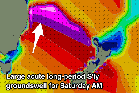
Our large long-period S'ly groundswell is still on track, with the Mid North Coast likely too see some late size across south magnets, with a peak due Saturday morning.
A severe low has been generating a fetch of storm-force W'ly winds along the polar shelf and satellite observations of this low are great. We'll see the system weaken ever so slightly while projecting east-northeast towards New Zealand this evening and tomorrow morning.
The long-period nature of the swell will likely see it focussing into some regions and not others, but keeping this in mind, south magnets south of Byron are likely to inconsistent but powerful 4-6ft sets Saturday morning, easing back through the day under a light W'ly offshore wind, giving into a S/SE change midday.
The Goldy isn't likely to pick up this swell very well at all, with northern ends and magnets coming in at 2-3ft.
Smaller leftover 3ft sets are due across south magnets on the northern NSW coast Sunday morning with a W/SW breeze, but later in the day another pulse of S'ly groundswell is expected peaking Monday morning.
This will be generated by a strong low pushing past the south-east corner of Tassie while producing a fetch of gale to severe-gale SW winds.
Size wise we're probably looking at 4-5ft sets across south magnets Monday morning with a W/NW offshore, but we'll have another look at this Friday.
Monday's swell will likely signal the start of a prolonged period of S'ly groundswell energy as a strong node of the Long Wave Trough sits across the Tasman Sea, directing front after front up through our southern swell window.
The models are still shifting around regarding the timing and strength of polar fronts being projecting through our southern swell window, but there'll be no lack of swell next week. Check back Friday for the latest on this southerly swell regime.


Comments
Being a surfer on the Sunny Coast is painful at the best of times, but to go from Spring straight to Winter is just plain cruel. Fuck you Huey, fuck you.
"....Yesterday's large pulse of expected S/SE groundswell only really impacted the Mid North Coast, with smaller surf seen further north, ..."
Fucken tell me about it. What a let down. I had my big board ready to go only to find small fat crap. Big board still came in handy tho. Oh well, maybe next time
Yeah surprising seeing as it was well aimed and came in strong across southern NSW.
This forecast has made me think about the bloke paddling a sea kayak to New Zealand, he left a week or so ago from Coffs and is probably right in the middle of the purple blob, terrifying stuff.
Been thinking same thing this bloke will be getting Hammered and probably be needing another rescue
Craig what would be the ideal months to do this Voyage ?
Well spring/summer and early autumn I'd say not ideal as going against easterly trades and north-east winds.
Later autumn and winter under a zonal westerly flow would be ideal I'd guess, but you'll probably also encounter south swell on the way over. Wouldn't want to paddle into a Tasman Low.
Scott Donaldson- took 10 days to paddle to Lord Howe. Now waiting for clear weather to paddle on. Has a website and tracker.
Thank f*ck I bought a new mountain bike. This surfing business is too bloody frustrating!
Swell didn't really impact on the Mid Nth Coast where I was! Checked several breaks & no where was really pumping! Might get a M'nt bike too!
I just got new forks and tyres for my mountain bike.
Lord Howe would be a nice stop over for old kayaker mate but he is going to have to veer south a fair bit to hit NZ.
Willy Weather / Lord Howe showing 3 - 4.5 mt sth sth west swell for about the next 7 days