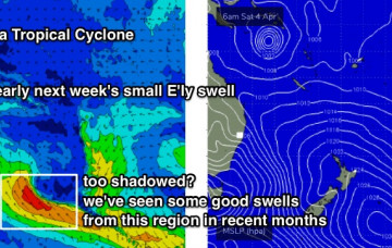
Model guidance is also suggesting a tropical cyclone may form in the Coral Sea this weekend. More in the Forecaster Notes.
Primary tabs
It will be worth keeping an eye on our far eastern swell window for the long term period. More in the Forecaster Notes.
There's a bevy of trade swells on tap for SE Qld, and we also have more southerly swell on the way - but mainly for Northern NSW. More in the Forecaster Notes.
The weekend looks a bit tricky, but there is certainly some potential for good waves as our eastern swell window lights up again. More in the Forecaster Notes.
It’s been a great week of east swell, eh? Unfortunately, we are now well and truly on the backside of this event. But, there's plenty of south swell on the way. More in the Forecaster Notes.
Looks like more E’ly swell for the rest of the week. But there's a few risks in the wind department. More in the Forecaster Notes.
Gusty S/SE winds will persist through Tuesday and Wednesday throughout SE Qld and Far Northern NSW, maintaining great waves at various points where the sand is stacking up properly. More in the Forecaster Notes.
Synoptically speaking, Saturday will mark a somewhat low point between this week’s windy conditions, and a fresh run of S/SE gales throughout the region. More in the Forecaster Notes.
Looks like a whole week of continuing windy weather ahead for SE Qld and Far Northern NSW. And potentially some large swell in the mix too. More in the Forecaster Notes.
A strong ridge will remain anchored across southern Queensland for the next few days, maintaining fresh to strong S/SE thru’ SE winds throughout SE Qld and Far Northern NSW. More in the Forecaster Notes.

