Less favourable winds but plenty of swell

Western Australian forecast by Craig Brokensha (issued Friday March 21st)
Best Days: Tomorrow morning in the South West, Monday morning in the South West, Tuesday morning, Wednesday morning in the South West
Features of the Forecast (tl;dr)
- Moderate sized mix of swells for tomorrow PM with mod-fresh SE tending stronger S-S/SW winds in the South West, SW to the north
- Easing swell Sun with strong S/SE winds
- Large mix of SW swells building Mon PM (peaking overnight) with moderate to fresh SE tending strong S/SW winds
- Easing swell Tue with gusty S/SE-SE winds in the South West, strengthening (E/NE winds to the north)
- Smaller Wed with morning E/SE winds
Recap
Our new mid-period SW swell pulsed a little better than expected across the South West with great 6-8ft sets under improving offshore winds, providing pumping surf through the day with sea breezes only kicking in mid-afternoon. The metro regions kicked to 2ft or so with the size easing back through tomorrow.
Winds were a little less favourable at dawn but improved through the morning with the swell still coming in around 6ft in the South West.

Great surf yesterday
This week and weekend (Mar 22 - 28)
Local conditions on the weekend won’t be as favourable as the last couple of days, with tomorrow morning being the pick with a fresh SE'ly that will strengthen from the S-S/SW in the South West, and go onshore to the north.
This will spoil a good mix of new mid-period SW swell and S/SW swell that’s due into the afternoon, generated by a frontal progression that’s currently south of us.
The earlier stages of the progression generated a fetch of strong to gale-force winds, producing a mid-period swell, while stronger core winds later in our swell window should produce a touch stronger S/SW swell.
Building sets to 5-6ft are due in the South West with 1-2ft waves to the north, easing back through Sunday from a slightly smaller size.
Winds will become stronger and less favourable from the S/SE on Sunday, which isn’t great with the swell mostly coming from a more southerly direction.
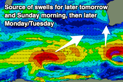
Winds look to swing back to the south-east through Monday morning and we’re due to see a large, inconsistent SW groundswell into the afternoon, generated by our strong polar low that’s currently weakening over the Heard Island region.
The low has been generating a great fetch of severe-gale W’ly winds (with a couple of storm-force barbs observed by satellite) and will slowly weaken while tracking east-northeast over the weekend.
We should see a large mix of inconsistent SW groundswell and some mid-period energy in the mix, building later Monday to 8ft in the South West ahead of a peak overnight (8-10ft).
Tuesday looks to offer 8ft surf, easing through the day with 2-3ft waves across Mandurah and 2ft+ surf across Perth.
Sea breezes will spoil the new swell into the afternoon with Tuesday coming in OK but not great thanks to gusty S/SE-SE breeze in the South West, cleaner to the north under E/NE breezes.
Wednesday looks much cleaner but the swell will be fading and only likely 4-5ft in the South West with 1-2ft leftovers to the north.
The rest of the week remains lack lustre with no major swell due but with good, clean conditions both Thursday and Friday mornings. More on this Monday, have a great weekend!