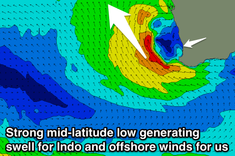
Easing swell all weekend, clean Sunday morning and fun Monday
Western Australia Surf Forecast by Craig Brokensha (issued Friday 22nd September)
Best Days: Sunday morning, Monday morning
Recap
Poor building onshore surf yesterday with strengthening onshore winds, large and to 10ft across the South West this morning, 3-4ft around Mandurah and 3ft in Perth as a strong mid-latitude low pushes across us.
The swell will build further this afternoon as the strongest winds associated with the low move across us.
This weekend and next week (Sep 23 – 29)
The intense mid-latitude low that's currently pushing across us will move off slowly to the east tomorrow and with this we'll see the stormy windswell back off steadily.
Conditions will remain poor tomorrow with fresh to strong W/SW tending SW winds, while Sunday is looking clean with variable tending light offshore breezes as another mid-latitude starts to develop to our west.
Margs should ease back from the 6-8ft range tomorrow, with Sunday coming in much smaller and around 4-5ft. Perth and Mandurah will still be size with easing 4ft sets tomorrow, back to 2ft Sunday.
 Monday looks to remain clean with an E'ly offshores feeding into the deep low which will generate strong winds aimed away from us and towards western Indonesia.
Some small W/SW swell from the initial stages of the low is due though, keeping the South West up around the 4ft range with 2ft waves around Perth and Mandurah.
The low is forecast to slowly move east on Tuesday which will result in strong SE winds across our region, tending to the S/SW Wednesday with no new swell.
Longer term we're due to see some fun S/SW groundswell from later in the week/next weekend as a series of vigorous polar fronts fire up through our southern swell window under the effects of the Long Wave Trough.
These swells will favour the South West over Perth and Mandurah but we'll have a closer look at this Monday. Have a great weekend!

