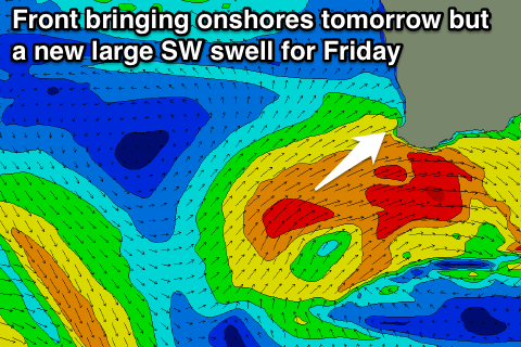
Large and onshore tomorrow, improving from Friday
Western Australia Surf Forecast by Craig Brokensha (issued Wednesday 25th June)
Best Days: Friday in protected spots, Saturday, Sunday, Monday morning in protected northern corners
Recap
Perth and Gero offered the best waves through yesterday with a dropping but fun swell and offshore winds. In Margs conditions were poor with unfavourable N'ly winds.
This morning the surf has bottomed out but conditions were better in the South West with a morning E/NE'ly and 4-6ft of swell, while Perth was still fun and around 1-2ft and Gero offered more size with fresh NE winds. A late and strong pulse of W/SW groundswell is still on the cards across the state and some new strong lines are starting to show on the cams, but the bulk of the swell is due through tomorrow.
This week (Jun 25 -27)
A very large and powerful W/SW groundswell that will impact Indo and arrive later today across our state should peak through tomorrow to an inconsistent 12ft to occasionally 15ft in the South West, 3-4ft in Perth and 6-8ft around Gero tomorrow morning.
 Conditions will be poor though with a fresh to strong W/NW tending W/SW breeze around Margs, W/SW tending SW winds in Perth and SW winds up at Gero.
This will be related to a vigorous mid-latitude front pushing into us, but this should also generate a secondary large SW groundswell for later in the day and Friday morning.
The size of this swell is expected to be under model forecasts as they're erroneously combining the easing long-period groundswell from the Indian Ocean with the new SW swell.
Margs is expected to drop from 10ft+ with 3ft sets in Perth and 6ft+ surf up at Gero. Winds should improve from Thursday and swing S/SE across Perth and Gero, while Margs may see an early S'ly tending more S/SE towards the evening, favouring protected bays and points.
This weekend onwards (Jun 28 onwards)
The weekend is still looking great as the swell continues to drop under offshore winds across nearly all regions. It may take a few hours for the exposed reefs around Margs to clean up so mid-late morning is likely to be best.
Come Sunday fresh E/NE tending NE winds should continue to create clean conditions as the swell continues to drop.
Later Sunday we may see a long-range SW groundswell fill in and this should keep fun waves hitting all coast into Monday to 4-5ft around Margs, 1-2ft in Perth and 3ft+ up at Gero. Winds may become an issue as a surface trough deepens off our north-west resulting in fresh to strong N/NE winds.
Longer term we should see a new large SW groundswell filling int Wednesday afternoon and then easing slowly Thursday under offshore winds but we'll look as this in more detail on Friday.

