Indonesia/Maldives forecast Mar 6
Indian Ocean Basin analysis by Craig Brokensha (issued Thursday 6th March)
This week through next ( Mar 7 -14)
The background S/SW swell into Tuesday provided fun waves before easing yesterday and further into this morning.
We then look at the expected S/SW swell due overnight tonight, with a peak through tomorrow across eastern Indonesia, more so into the afternoon to the west.
This swell, which was generated by a healthy but not overly strong frontal progression projecting towards Western Australia over the weekend and Monday came in well across that state yesterday and should push to 6ft+ across exposed breaks in Bali through tomorrow.

This will then ease slowly through the weekend and further Monday.
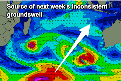
The larger, stronger but less consistent S/SW groundswell for early-mid next week is still on track, with the strong polar low linked to it generating a great fetch of severe-gale W’ly winds while moving east across the Heard Island region.
The low will weaken a touch while projecting more east-northeast today, with the swell due to arrive through Tuesday afternoon, peaking later but holding into Wednesday morning.
The size will ease slowly through the end of the week, with a possible, new moderate sized SW groundswell due next weekend. The models align regarding the polar low linked to it but we’ll confirm things next update.
In the Mentawais, the fetch of weak but stationary W’ly winds west of the islands through this week have generated a small to moderate sized W’ly swell that’s on the build today and will ease slowly through tomorrow and the weekend.
Winds should ease and tend variable from tomorrow, with freshening S/SE-SE winds across northern and central locations Saturday, shifting more to the north Sunday, weakening next week.
----------------------------------------------
Maldives:
There’s been no changes to the good increase in S’ly groundswell due through tomorrow, peaking later and then easing into Saturday.
The secondary pulse of S’ly groundswell for later Monday and Tuesday morning is also on track, generated by the strong polar low currently around the Heard Island region.
For the central and northern regions, the SE trade-swell due to slowly increase through the weekend but show its head more into next week is on track as well.
Currently a healthy fetch of E/SE-SE trades are being established through the Indian Ocean, with a tropical depression likely to deepen in the flow through the weekend. This will create stronger levels of S/SE swell through next week, arriving from Wednesday and persisting through the end of the week.
The possible formation of a tropical cyclone would generate some stronger S’ly groundswell Friday but we’ll review this next week.
Eastern Indonesia:
Moderate + sized, mid-period S/SW swell for tomorrow, reaching 6ft+ across exposed breaks during the day.
Easing surf on the weekend.
Moderate-large, inconsistent S/SW groundswell building Tuesday, reaching 8ft late, easing from a similar size Wednesday morning.
Light, local offshore winds ahead of weak if not variable sea breezes
Uluwatu 16-day Forecast Graph/WAMs
Western Indonesia/Mentawais/South Sumatra:
Building W’ly swell this afternoon, reaching 4ft at its peak tomorrow, easing slowly on the weekend.
Moderate sized, mid-period S’ly swell for Friday to 4-5ft+ across exposed breaks into the afternoon, easing Saturday.
Moderate-large, inconsistent S/SW groundswell for later Tuesday and more so Wednesday morning to 6ft+ across exposed breaks.
Variable winds tomorrow, freshening from the S/SE-SE across central and northern locations Saturday, migrating more to the north Sunday. Lingering S/SE-SE winds early next week, tending variable thereafter.
Mentawai 16-day Forecast Graph/WAMs
Maldives:
Small to moderate sized S’ly swell building to 3-4ft on the southern atolls tomorrow afternoon, easing Saturday.
Inconsistent S’ly groundswell for later Monday but more so Tuesday morning to 3-4ft+ on the southern atolls.
Slowly building S/SE-SE trade-swell from the weekend, reaching 4ft+ early next week,
Stronger swell from the S/SE through the middle to end of next week and to 4-5ft, possibly building further Friday.
Variable winds, tending N/NE on the weekend and freshening from Sunday through early next week. Winds easing and tending more E/NE then E/SE through Tuesday/Wednesday.


Comments
Latest notes are live.
Pumping this arvo Craig some double overhead sets, 4-6 wave reasonably consistent sets . Be interested to read how evo went, some spots in Bali must have had a bit of size .
Awesome, thanks Supa!
Unfortunately because I travel on Qantas staff travel the flight I was to
travel on out of Sydney was suddenly over booked I would say because
of cyclone Alfred the Brisbane flights cancelled. Now waiting for next round
of swell for a week to try attempt No 3. Im starting to feel Bali dosent want me back.
Did you kill a china man or something evo ? you’re having a shocking run . Not to worry Wednesday looks like it will be pumping, still some size this morning but nothing like yesterday . Lacerations was solid stand up barrels yesterday arvo with 8 hot locals on it . Not as consistent as the wreck & mainly 4ft but 4 sets of size came through in an hour , so I’m told by the resident local champion . A few other spots like tamarind also lit up , 4-5 ft barreling left, 1 guy out having a ball . Wreck was a bit ugly and dangerous towards the late arvo , lots of water moving around and there’s a ledge you can get sucked into if you’re not familiar with the set up . This arvo should be fun.
Stoked
Been in the hills for a month and ready to go
Good to see my analysis confirmed
Typing this sitting at Kualanamu
Surfing tomorrow
Couple fun ones this morning.

Whats happened to the surf reports I still wish to go?
I think Craigs away .
@evo , we have had easterlies for a few weeks now but it’s back to westerlies this weekend, looks like a good pulse starting Sunday , low tides early morning.

When are the surf forecast coming back?