Less favourable outlook so make the most of tomorrow

Victorian forecast by Craig Brokensha (issued Friday March 21st)
Best Days: Tomorrow Surf Coast, Sunday morning for the keen, Friday morning next week
Features of the Forecast (tl;dr)
- Easing W/SW-SW swell tomorrow with W/NW winds, tending S/SW from late AM but without much strength
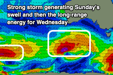
- Moderate + sized SW groundswell building rapidly Sun, peaking in the PM, easing Mon
- Light-mod S/SE-SE winds Sun, freshening into the PM
- Light-mod S/SE tending S/SW winds Mon
- Small-mod sized W/SW swell Tue with E/SE-SE tending S winds
- Inconsistent, moderate sized W/SW groundswell building Wed with freshening S winds
- Easing swell Thu with S/SE-SE winds
- Smaller Fri with gusty E-E/NE winds ahead of sea breezes
Recap
Early yesterday was great across the Surf Coast with clean, easing surf from 3-5ft under a freshening offshore winds, smaller through the afternoon but still decent as winds shifted more west.
To the east the swell was a bit too solid for the beaches but there were options for the savvy.
This morning conditions are fairly ordinary following an evening change with onshore winds and surf to 3ft and 4-5ft respectively west and east of Melbourne. We should see some new mid-period swell building through the afternoon, reaching 3-4ft on the Surf Coast and 6ft to the east as winds hold from the S-S/SE.
This weekend and next week (Mar 22 - 28)
Tomorrow looks to be the pick of the weekend with a light W/NW offshore due on the Surf Coast before reverting back to the S/SW later morning though without too much strength, similar into the afternoon.
This afternoon’s building W/SW swell should start to ease back from a fun 3ft across the Surf Coast with 4-5ft+ sets to the east.
Into Sunday, our moderate + sized SW groundswell is on track, with the source currently strengthening of Western Australia.
A deepening low will project a great fetch of gale to severe-gale W/SW winds through our south-western swell window today before weakening this evening, with the swell due to arrive through Sunday morning before peaking during the day.
The Surf Coast should pulse to an easy 4-5ft+ with 6-8ft sets to the east and winds look less than ideal, light to moderate from the S/SE-SE, freshening into the afternoon.
This will mostly spoil the new swell but the morning looks more than doable for the keen, while Monday will see lingering S/SE tending S/SW winds as the swell eases.
The reason for the persistent onshore winds will be thanks to a trough lingering in the region as high pressure remains stubborn and near stationary to our west.
This will see E/SE-SE winds persisting Tuesday along with a smaller reinforcing mid-period W/SW swell, while a stronger, long-range groundswell for Wednesday afternoon will remain under the influence of strengthening S’ly winds.
As touched on in Wednesday’s notes, the source will be long-range, with a strong polar low forming west of the Heard Island region earlier this week, projecting a slow moving fetch of severe-gale W’ly winds eastward. The low will slowly weaken and track east-northeast today and through the weekend, with the inconsistent groundswell due to build through Wednesday and reach an inconsistent 4ft on the Surf Coast and 6ft+ to the east.
Winds look to ease temporarily into Thursday as the swell eases but linger from the S/SE-SE, with Friday possibly finally seeing winds tend E-E/NE as the swell continues to back off. We’ll confirm this next week.
Longer term it looks like high pressure and winds from the south-eastern quadrant will dominate the period, with a return to a summer like pattern. Have a great weekend!
Comments
Geez this one kicked a bit more than forecast.
How big did it get? 6-8ft Surf Coast? That low was quite intense.
West of the Cape 12+ range
Oh yeah, for sure.
Wport kicked mid afternoon and certainly delivered under a light onshore. Top end of PI woulda been firing.