Easing surf as conditions slowly improve

Victorian forecast by Craig Brokensha (issued Monday February 24th)
Best Days: This morning Surf Coast, Wednesday morning, Friday morning Surf Coast
Features of the Forecast (tl;dr)
- Easing W/SW swell tomorrow with light E/SE-E winds ahead of sea breezes to the east (moderate E/SE morning winds to the west)
- Smaller Wed with light, local offshore winds ahead of a strong S/SW change earlyPM
- Small Thu with lingering S winds
- Small-mod sized W/SW swell for later Thu, peaking Fri with W/NW-NW winds, tending fresh S/SW mid-PM
- Mod sized W/SW swell for later Fri but more so Sat with variable tending S/SE winds
- Moderate to large W/SW groundswell for Sun PM, easing Mon
- Mod-fresh S winds Sun S/SE Mon
Recap
Saturday was good to great across the state with peaky 2-3ft waves on the Surf Coast that were best suited to the beaches again while locations to the east were clean all day and a good 3-5ft with options all over.
A trough moving in through yesterday brought average conditions as the swell faded, while today we’ve got a pulse of new W/SW swell on the build under favourable morning conditions across the Surf Coast. We should see the Surf Coast reaching 4ft+ through the day (currently slow 4ft sets) with 6ft to occasionally 8ft sets to the east and winds will shift S/SW later morning before freshening into the afternoon. So try and get out this morning.
This week and weekend (Feb 25 - Mar 2)
The slow moving mid-latitude low linked today’s building swell has drifted away to the south-east, with high pressure due to move in behind it over the coming days.
This will allow winds to ease and shift more E-E/SE tomorrow morning to the east of Melbourne while remaining onshore across the Surf Coast.
The swell will start to ease with the Surf Coast due to drop back from 3ft tomorrow morning with 4-6ft sets to the east, best Wednesday as winds shift locally offshore during the morning (N/NW Surf Coast and N/NE to the east) before a trough brings a strong, S/SW change early afternoon.
The Surf Coast will only be small and easing from 2ft with great 3-4ft waves to the east.
Thursday looks like a lay day with lingering S’ly winds in the wake of Wednesday’s change, while only a small background swell is due to be in the water.
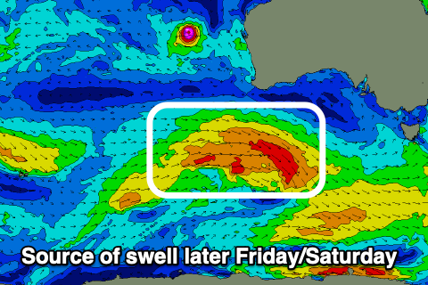
Into Friday, a small-moderate sized, mid-period W/SW swell is due, generated by a broadening but weak fetch of W/SW winds firing up under the country over the coming days.
The Surf Coast should see 2-3ft surf with 4-5ft+ sets to the east and a morning W/NW-NW breeze will favour locations west of Melbourne before shifting S/SW and with strength into the mid-late afternoon.
A secondary, slightly stronger pulse of mid-period W/SW swell is due later in the day and more so on Saturday, generated by a secondary slightly stronger but less favourably aligned frontal system moving under Western Australia on Wednesday.
Sets to 3ft are due off this system later Friday and Saturday on the Surf Coast with 4-6ft waves to the east and winds should become variable through the morning, creating mostly clean if not slightly lumpy conditions before S/SE sea breezes kick in.

We then look at a third, stronger system moving in from the south-west of Western Australia mid-late week. A tight low is due to produce a fetch of sever-gale to possibly storm-force W’ly winds while tracking east, expanding while weakening under the country.
This should generate a mix of mid-period and stronger groundswell for Sunday afternoon, building to 4-5ft on the Surf Coast and 6ft to occasionally 8ft to the east, but a trough moving through Saturday evening looks to bring unfavourable S’ly winds that will remain out of the S/SE as the swell eases next Monday.
Tuesday looks the pick as winds go back offshore, but this is a long way down the track so check back Wednesday and Friday for further updates.
Comments
Hey just wondering if you could clarify this statement next to the image, as it seems to sit inbetween southerly afternoon change and southerly day the next?
The Surf Coast will only be small and easing from 2ft with great 3-4ft waves to the east.
Sorry, that's Wednesday's outlook size wise, with the morning offshores ahead of the S/SW change.
Swell completely died in the arse on Monday ,was just hoping for a decent size at Bells with a bit of an onshore by midday swell was virtually non existent, buggah !!
Bummer, west swells are never really that reliable eh. Just a quick spike and then gone.