Good surf tomorrow, deteriorating Sunday

Victorian forecast by Craig Brokensha (issued Friday February 21st)
Best Days: Tomorrow, Monday morning Surf Coast, Wednesday morning exposed beaches, Friday morning Surf Coast
Features of the Forecast (tl;dr)
- Small-mod sized mid-period S/SW swell for Fri PM and Sat, easing Sun
- Early, fresh NE winds tomorrow, strengthening from the N/NE through the day, back to the NE into the evening
- Light-mod W/NW-NW-N/NW winds on Sun AM, shifting W/SW through the late AM and stronger S/SW into the PM
- Mod + sized W'ly swell Mon with early W/NW (on the Surf Coast) tending S/SW later AM, freshening into the PM
- Easing swell Tue with moderate SE winds
- Easing swell Wed with NE-N/NE winds ahead of a late S/SW change
- Small, building W/SW swell Thu with S/SE winds
- Stronger SW swell building Fri with N/NW tending SW winds
Recap
The swell held up in the 3-4ft range across the Surf Coast yesterday with 5-6ft sets to the east but with mostly poor conditions thanks to a persistent, gusty onshore wind.
This morning the swell has eased back to 3ft on the Surf Coast and 4-5ft to the east but conditions are better and improving with lighter east winds. The beaches are the pick across all regions though a little chunky for some breaks to the east still.

Improving options on the beaches this morning
This week and weekend (Feb 22 - 28)
Tomorrow will be the pick of the weekend as winds shift around to the N/NE-NE and start strengthening (fresh at dawn), holding from the NE into the late afternoon/evening.
This will be along with reinforcing, fun levels of mid-period SW swell that’s due to arrive this afternoon and hold tomorrow morning, then easing later in the day, down further on Sunday.
The source of the mid-period energy has been persistent, drawn out fetches of W’ly winds on the polar shelf, maintaining the size through yesterday and this morning, with the Surf Coast due to continue around 2-3ft tomorrow with 4ft to occasionally 5ft sets to the east, easing Sunday from 2ft and 3-4ft respectively west and east of Melbourne.
Sunday now looks dicey to the east as an approaching mid-latitude low brings early NW-N/NW winds, shifting W/SW by late morning and strengthening into the afternoon from the SW-S/SW.
Looking at the swell generating low, and while it was never looking amazing for swell production, the core wind speeds have been downgraded a little since Wednesday.
We’re expected to see strong to gale-force W/SW winds generated through our western swell window from this afternoon (south of Western Australia) through tomorrow as it moves through the Bight, pushing closer to us Sunday while slowly weakening.
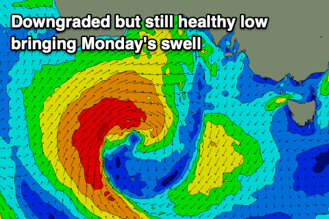
A moderate + sized W/SW swell is still expected on Monday, peaking through the day to 4ft+ on the Surf Coast magnets with 6ft to occasionally 8ft waves to the east, easing Tuesday from 3ft and 4-6ft respectively.
Local winds on Monday should be W/NW early, creating good, clean conditions but make the most of it as a shift to the S/SW is due later morning (without too much strength) before freshening into the afternoon.
High pressure will fill in behind the low on Tuesday resulting in moderate S/SE-SE winds as the swell eases, better Wednesday as winds shift back to the NE and the size continues to fade.
Moving into the end of the week and a strengthening frontal progression passing under the country should generate healthy levels of mid-period SW swell, while of greater significance is a possible stronger low firing up under the country into next weekend. More on this Monday, have a great weekend!