Hit the beaches before attention swings to the Surf Coast

Victorian Forecast by Craig Brokensha (issued Friday December 6th)
Best Days: This morning exposed beaches, Sunday morning Surf Coast, Monday morning Surf Coast and then every morning thereafter next week for the Surf Coast
Features of the Forecast (tl;dr)
- Low point in swell tomorrow AM, with a moderate sized mid-period W/SW swell for the PM, easing Sun AM
- Early N/NE-N/NW winds tending W/NW late AM ahead of a stronger SW change into the PM
- Building W/SW swell Sun PM with a moderate sized mid-period SW swell peaking Mon AM
- Moderate W/NW tending gusty S/SW winds later AM Mon
- Slightly smaller Tue with W/NW tending S/SW winds
- Reinforcing mid-period SW swell Wed/Thu, with a long-range W/SW groundswell in the mix Thu
- W/NW tending fresh SW winds
Recap
The beaches to the east have been the standout the last two days with a moderate sized mid-period W/SW swell to 4ft+ yesterday while the Surf Coast was mostly 2ft with Barwon Heads coming in more to 2-3ft.
This morning the swell is on the ease but conditions are good again but we’ll see a shallow change early afternoon, weakening thereafter.
This weekend and next week (Dec 7 - 13)
We’ve expecting a low point in swell tomorrow morning and early N/NE winds will create clean conditions to the east, N/NW to the west, shifting W/NW by later morning ahead of a SW change that will strengthen into the afternoon.
The timing of the change looks to be right when a good, new mid-period W/SW swell starts to arrive, with it generated mid-week by a healthy fetch of W/SW winds to the south of Western Australia.
This should see sets building to 3ft on the Surf Coast with 4-5ft+ waves to the east, easing off from 2-3ft and 4-5ft respectively west and east of Melbourne Sunday morning.
Winds are due to be fresh out of the W/NW Sunday morning before reverting back to the SW during the morning and strengthening. This will be as secondary healthy frontal system moves in under the country, generating a great fetch of W/SW winds tomorrow, with the fetch strength reaching near gale-force early Sunday.
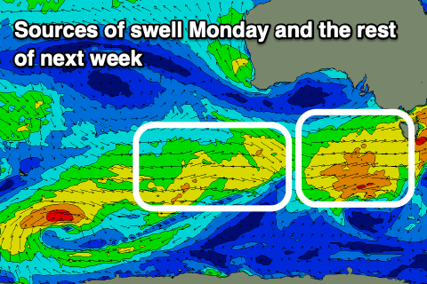
This has been upgraded and we should see a moderate sized, mid-period SW swell from this system with building surf Sunday afternoon, peaking Monday to 4ft on the Surf Coast and 6ft to the east through the morning, easing into the afternoon and further Tuesday.
Winds look great early and moderate from the W/NW but will shift S/SW later morning and freshen through the afternoon as a trough moves through.
This looks to leave lingering S’ly winds into Tuesday as the swell starts easing, though without much strength there should still be some OK waves around.
The second half of the week looks to consist of small to moderate levels of mid-period swell (2-3ft range Surf Coast) with W/NW to SW winds as weak, persistent fronts move in under the Bight and across us.
There’ll also be a long-range W/SW groundswell signal in the water later Wednesday but more so Thursday though its source, in our far swell window (north of Heard Island) probably won’t amount to much.
Longer term, things slow down a little into next weekend and early next week but more on this Monday. Have a great weekend!
Comments
Thanks Craig, the Surf Coast could do with a few decent days. It has been pretty average since our great run in September. The MP and PI have had a number of good days by the looks of things, which is what you would expect this time of year with Easterlies etc. Good luck to them.
Hey Craig here's the large scale synoptic explanation explaining why it's been QLD style humid down here for the last 3 weeks:
https://www.abc.net.au/news/2024-12-07/australia-weather-thunderstorms-f...
Record sea temps off the NW and gulf, up north.
There's been a decent number of northerly days compared to the La Nina summers, been enjoying the small, shapely beachies and warmth, didn't expect it with the humidity though!
Yep north-west moisture being transported down off those very high SSTs.