Best now and tomorrow morning
Victorian Forecast by Craig Brokensha (issued Friday November 22nd)
Best Days: This morning, tomorrow ahead of wind shifts, next Friday
Features of the Forecast (tl;dr)
- Small-mod sized S/SW swell tomorrow, easing Sun
- Fresh N/NE winds to the east (N-N/NW to the west) tomorrow AM, shifting W/NW into the PM ahead of a S/SW change before dinner
- Lingering S/SE winds Sun AM with easing levels of swell
- Small Mon with moderate S-S/SW winds
- Moderate sized W/SW swell building Tue PM with moderate S/SE winds, freshening through the day
- Easing surf Wed with moderate S/SE winds, freshening through the day
- Strengthening SE winds Thu with a building windswell, easing Fri with N/NE winds
- Moderate sized, inconsistent W/SW groundswell building Fri PM, easing Sat
Recap
Yesterday started small and average on the Surf Coast with better options to the east, and into the afternoon some new but inconsistent SW groundswell started to show.
This morning is the pick of it though with cleaner conditions on the Surf Coast and lined up 3ft sets while to the east there’s 4-5ft of swell under offshore winds. Make the most of this morning’s conditions as the swell will ease into the afternoon along with freshening SE sea breezes.

Fun surf this morning
This week and weekend (Nov 23 - Dec 6)
The current long-range swell will ease into the weekend, but our reinforcing pulse of S/SW energy for tomorrow looks on track, with a deepening but east-southeast tracking low pushing through our southern swell window the last couple of days.
It was strong but small in scope and with this we can expect surf to hold the 2-3ft range on the Surf Coast tomorrow (more consistent 3ft magnets) with 4ft+ sets to the east.
Local winds will have a bit of north in them still favouring selected breaks to the west and being great for the beaches to the east in the morning before shifting W/NW into the afternoon ahead of a S/SW change before dinner. Therefore hit the beaches to the east up early for the cleanest conditions.
Unfortunately Sunday now looks a little dicey as the forecast variable winds now look to linger out of the S-S/SE, only light in nature. It’ll still be surfable but with the smaller, easing swell not great.

Sunday’s winds will signal the start of an average run of conditions and surf into next week as the trough responsible for it lingers in the region, squeezing against high pressure to the west.
Moderate S-S/SW winds are due on Monday with a low point in swell, while lighter winds might be seen into Tuesday though out of the S/SE, freshening through the day (similar Wednesday).
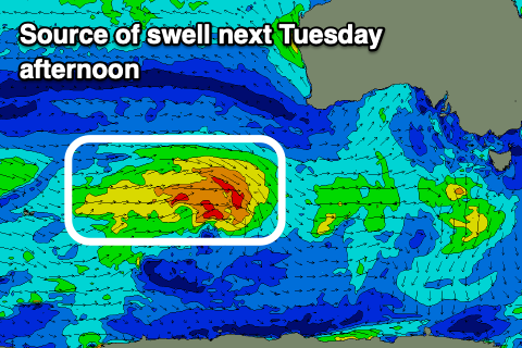
Swell wise, a new mid-period W/SW swell is due into Tuesday afternoon and Wednesday morning, generated by a small but healthy frontal system tracking from the south-west of Western Australia today, under the country on the weekend.

Building sets to 3ft are due on the Surf Coast into Tuesday afternoon, easing Wednesday with those persistent S/SE-SE winds.
The trough will deepen later week and winds will strengthen further from the SE, kicking up some building SE windswell Thursday, with Friday seeing a shift in winds back to the N/NE with fun peaky options as a long-range W/SW groundswell also fills in.
The source of the groundswell will be a strong polar low around the Heard Island region, with moderate sized surf due to build through the day, likely reaching 3-4ft on the Surf Coast and 6ft+ to the east. More on this Monday, have a great weekend!

