Good waves for the Surf Coast this coming period
Victoria Forecast by Craig Brokensha (issued Friday 9th June)
Best Days: Both coasts Saturday, Surf Coast Sunday through all of next week
Recap
Good clean conditions across the Surf Coast all of yesterday with easing 2ft sets, while the Mornington Peninsula was bumpy and average, cleaner on Phillip Island.
A strong onshore change moved through overnight and this morning we're left with poor conditions but some new mid-period W/SW swell.
We should see stronger levels of less consistent W/SW groundswell building through this afternoon as winds relax creating a slight improvement in conditions.
This weekend and next week (June 10 – 16)
This afternoon's strong W/SW groundswell has hit South Australia and will push in this afternoon across our coasts, reaching 4ft on the Surf Coast and 6ft to occasionally 8ft on the Mornington Peninsula as S'ly winds ease.
Tomorrow morning should still reveal solid sets, easing from 4ft on the Surf Coast and 6ft+ across the Mornington Peninsula and conditions will be much cleaner with variable winds expected from this evening, remaining so into most of tomorrow if not tending light W/NW. This will favour the Surf Coast with good fun waves due all day.
The easing trend will be slowed through Sunday, with a reinforcing kick into the afternoon, generated by fetches of pre-frontal W/NW gales through our swell window today and tomorrow.
This should keep 3ft sets hitting the Surf Coast along with 4-5ft+ waves on the Mornington Peninsula Sunday, easing slowly Monday.
 Our models are incorrectly combining this reinforcing swell with some W'ly windswell Monday morning, over forecasting the size a little. We're likely to see easing 2-3ft waves on the Surf Coast and 4-5ft waves on the Mornington Peninsula.
Winds on Sunday are now due to be moderate to fresh from the N/NW tending NW which will favour the Surf Coast over the Mornington Peninsula, while W/NW winds are due Monday, giving into a late W/SW change.
This change will be linked to a weak front moving moving through, bringing a small mid-period W/SW swell for Tuesday. Also in the mix will be a very long-range W/SW groundswell but to no major size.
The Surf Coast is only due to see infrequent 2ft sets with 3-5ft waves on the Mornington Peninsula under a W/NW tending variable breeze.
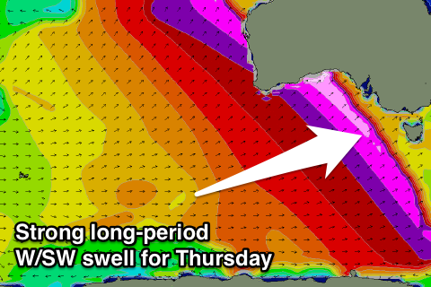
Longer term our eyes look towards a strong and powerful W/SW groundswell due Wednesday afternoon and more so Thursday.
This swell will actually be linked to the large pumping swell seen at Skeleton Bay, with the storm generating this swell drifting south-east from South Africa, into the Southern Ocean before re-intensifying in the Heard Island region.
Various bursts of severe-gale westerly winds will be aimed through our far western swell window, with core wind speeds reaching the storm-force range. We'll see this progression tracking east slowly over the weekend before weakening later Monday.
An inconsistent long-period and long-range W/SW groundswell will result, building later Wednesday ahead of a peak Thursday to 3-4ft on the Surf Coast and 6ft+ on the Mornington Peninsula. There are likely to be a few bigger sets at times and N/NW winds will favour the Surf Coast over the Mornington Peninsula.
Beyond this some closer storm activity is due to generate some good new swell next weekend and beyond, but more on this Monday. Have a great weekend!


Comments
What keeps changing the models calling NE/ENE to west?