Good week ahead with plenty of swell
Victoria Forecast by Craig Brokensha (issued Monday 13th February)
Best Days: Surf Coast tomorrow, selected locations to the east through the day, both coasts Wednesday, both coasts Thursday morning and Friday morning, Surf Coast Saturday and Sunday mornings
Recap
Tiny clean waves Saturday morning on the Surf Coast and poor bumpy conditions to the east, while Sunday saw a mix of better W/SW swell and building windswell coming in at 3ft on the Surf Coast, larger into the afternoon.
Today a moderate to large S/SW groundswell from the strong cold front pushing up and into us has come in as expected, but unexpectedly the Torquay region saw an early W/NW offshore wind, creating good conditions before winds tended back to the W/SW with strength.
This early W/NW'ly was a result of the positioning of the front in the wake of yesterday's change being more favourable than forecast on Friday morning.
This week (Feb 14 - 17)
Today's sizey S/SW swell is expected to peak this afternoon, dropping off gradually through the coming days with lighter winds tomorrow, offshore Wednesday.
The Torquay region should see an early W/NW'ly again tomorrow with easing 3-5ft sets, 6ft to occasionally 8ft on the Mornington Peninsula but with a moderate and easing S/SW breeze.
Winds are expected to remain light into the afternoon, creating workable conditions at selected breaks on both coasts most of the day.
Wednesday will be great with a freshening N/NE tending N/NW breeze, easing later ahead of a late change.
 The Surf Coast is looking good with easing 3ft sets, with 4-5ft waves on the Mornington Peninsula.
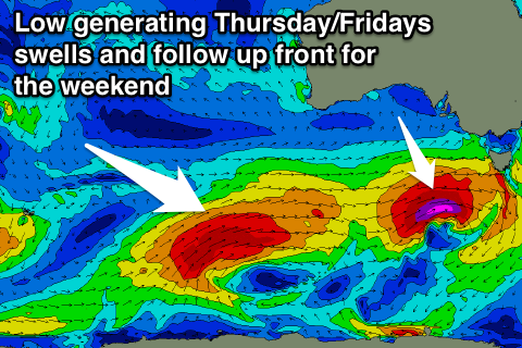
Wednesday's late change will be linked to an approaching and strengthening frontal system south of the Bight.
This front will generate an initial weak fetch of W/SW winds through our western swell window, strengthening to the severe-gale range through our close-range south-west swell window on Wednesday.
This should generate a moderate to large SW groundswell, building Thursday afternoon, peaking overnight and easing Friday.
Size wise the Surf Coast should build to 4-5ft later Thursday, easing from 3-5ft Friday morning, with 6-8ft sets on the Mornington Peninsula.
A secondary broader, weaker but slow moving polar frontal system will generate additional W/SW tending SW swell for the weekend, but we'll have to have another look at this on Wednesday.
Winds on Thursday are looking variable through the morning ahead of sea breezes, similar into Friday morning (tending W/NW) ahead of the approaching front.


Comments
Yiewwwwww best news! Cheers for this Craig