Solid S'ly swell mixed with smaller E'ly energy
Sydney, Hunter and Illawarra Surf Forecast by Guy Dixon (issued Wednesday 13th July)
Best Days: Thursday, Friday morning and Saturday morning
Recap:
Options slowly faded from the 2-3ft range across open beaches on Tuesday as left over easterly energy faded. By the afternoon, inconsistent 2ft sets were breaking, which have eased further today to the occasional 1-2ft range.
Conditions have remained clean for the most part under a northwesterly breeze, tending chilly west/northwesterly today.
This week (Thursday 14th - Friday 15th):
Following today's low point in swell, we are due to see a mix of building southerly and easterly energy.
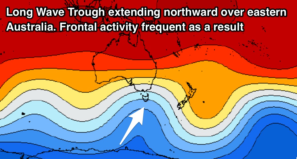
First off, frontal activity looks to increase over eastern Australia primary due to a strong node of the Long Wave Trough shifting over the region.
Overnight, we saw pre-frontal northwesterly fetches off the coast of Tasmania tend southwesterly, becoming more aligned for the NSW coast. While this alignment could be better, the strength, breadth and persistence of these fetches are likely to deliver plenty of good southerly energy for the end of the week and across the weekend.
 Multiple intensifications of southwesterly winds up to 50kts+ are expected to whip up groundswell to around 3-5ft across south facing beaches for Thursday morning, larger across the Hunter. The swell should kick a little stronger through the afternoon from when the fetch is best aligned in our swell window this afternoon. The Hunter will be larger with 6ft sets developing, while smaller surf is due on the South Coast due to the swell being generated in close proximity.
Friday should see a strong period pulse move up the coast generated by yet another slingshotting intensification, with solid options in the 4-5ft range, holding into the afternoon, larger across the Hunter and smaller on the South Coast.
Meanwhile, easterly energy which has been traversing the northern Tasman Sea over the past few days generated by the eastern most fetches of last week’s low as it moved east of New Zealand. This swell should provide inconsistent, less significant sets in the 2-3ft range at open beaches on Thursday and Friday - a good source of energy for those spots that will miss out on the southerly groundswell.
Brisk westerly winds are likely to keep conditions clean and groomed on Thursday and Friday morning, only easing and potentially swinging southeasterly on Friday afternoon.
This weekend (Saturday 16th - Sunday 17th):
South facing beaches will likely offer solid sets in the 4-5ft range on Saturday morning off the back of Friday afternoon’s strong pulse, easing steadily thereafter as frontal activity dies down.
Sunday should see south facing beaches ease from around 3ft, with the Hunter once again offering more size.
Easterly energy will also be on an easing trend, remaining inconsistent, easing from around 2ft on Saturday morning, becoming small and insignificant on Sunday.
Southwesterly breezes are on the cards each morning (potentially light/variable on Sunday morning) before tending light onshore each afternoon, from the southeast on Saturday and northeast on Sunday afternoon.
Next week (Monday 18th onward):
Each swell window looks to remain fairly quiet/unfavourable until later on Monday into Tuesday when strong southwesterly trailing fetches intensify following a front. At this stage, it looks like we are due to see the swell build into the afternoon on Tuesday before easing on Wednesday.
More detail on this system as the situation develops.


Comments
Are you guys ever going to make your LWT graphs available?
Yeah, it's on the to-do list. Requires a reconfiguration of our WAMS pages which is why it can't be done easily. Hopefully will knock it off soon.
Got ya - fun job.
On another note the MJO affects cyclone formations during summer - does it impact ECL formation during winter or is that more random?
Guy what size do you except the south coast (Wollongong area) sat morning? thanks mate
Newcastle looking primo this afternoon.
https://www.swellnet.com/surfcams/newcastle
Plenty of size at Shark Island.