Plenty of good options to come; a mix of E'ly and S'ly swell with offshores persisting
Sydney, Hunter and Illawarra Surf Forecast by Guy Dixon (issued Monday 11th July)
Best Days: Each morning from Thursday
Recap:
It was a great weekend of waves along the NSW coast with a mix of strong southeasterly energy and fun east/southeasterly energy. Multiple pulses maintained options in the 4-5ft range on Saturday and Sunday, with a few magnets offering sets in the 6ft range, particularly along the Hunter.
Winds cooperated for the most part, starting off westerly each morning and remaining light despite tending seabreezey at times.
Today, the surf has eased somewhat with conditions deteriorating under a northerly airflow.
This week (Tuesday 12th - Friday 15th):
The swell is due to ease further throughout today and into Tuesday as trailing southeasterly and east/southeasterly fades. Residual energy should provide options in the 2-3ft range for the early session on Tuesday morning, but don’t expect it to hang around long. The easing trend looks steady and fairly rapid, so make the most of it while it lasts.
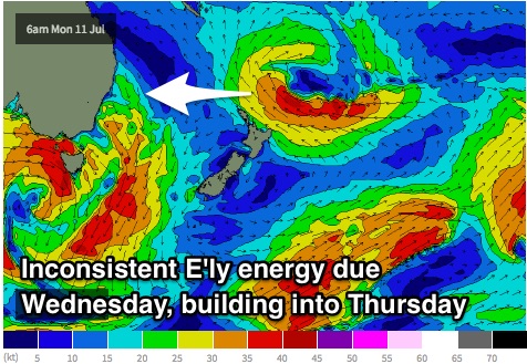
 The system responsible for the weekend's swell looks to linger behind the North Island of NZ, however the northern and eastern most extension of this fetch looks to be just in the NSW swell window. These fetches actually look fairly decent with 35-40kt core winds becoming elongated into Tuesday.
As a result, we can expect inconsistent easterly groundswell to build on Wednesday to around 2-3ft, increasing into Thursday to around 3ft+ and holding into the end of the week, smaller on the South Coast.
Meanwhile, much of eastern Australia will be under a pre-frontal northwesterly tending westerly airflow until late Tuesday evening before a fetch off the east coast of Tasmania swings west/southwesterly and intensifies while edging northward.
Core winds of 35-45kts are on the cards, followed by 45-50kt west/southwesterly core winds just to the south. The motion of this storm track is somewhat broad and semi-zonal (an arching motion as opposed to distinct northward slignshot), however we can expect a promising second half of the week with multiple pulses filling in across south facing beaches.
The prospects for decent southerly swell on Wednesday are somewhat limited, with the timing of winds swinging west/southwesterly cutting it pretty fine. I’d say the first increase in energy will fall under the cover of darkness, making Thursday a much better option.
South facing beaches should wake to sets in the 3ft range, kicking to 4-5ft by the late afternoon on Thursday as a period pulse fills in. As per usual, due to the aspect of the coastline, the Hunter should offer more size, perhaps up to 6ft on the sets.
Southerly energy generated by further intensifications over the Southern Ocean pushing up into the Tasman Sea should maintain options of a similar size on Friday.
Breezes should increase from the northwest throughout Tuesday, possibly tending north/northwesterly at times. Conditions should remain clean on Wednesday and Thursday as winds swing from west/northwesterly to west/southwesterly, only tending light onshore by Friday afternoon.
This weekend (Saturday 16th - Sunday 17th):
By the time the weekend comes around, it looks as though the strongest period pulse will have been and gone and we will entering an easing trend. Nevertheless Saturday morning should offer 3-5ft sets across south facing beaches, easing throughout the day.
Sunday should be offering 2-3ft sets, with the Hunter making the most of the left over energy.
Each morning of the weekend is looking clean under a west/southwesterly breeze, easing and tending southeasterly in the afternoon.
Next week (Monday 18th onward):
Into the start of next week, the swell windows look to quieten down allowing all swell sources to ease. More detail on Wednesday.


Comments
let the good times continue
do you think we'll see 2-3ft sets at dawn on Wednesday? Thanks guy
interesting w/e of surf reports. the reports were calling it 4-5ft. i copped some double overhead waves on the head at my local south facing beach. fair enough. today, 3-5ft according to the report.. hmm.. nowhere near the size of either Sat or Sun, swell size or breaking wave height. i appreciate period had a lot to with it. but i'd suggest using 'wave face' as well as swell size in the reports.
not sure where you surfed but there was definitely the odd 5ft bomb both days! I surfed twice each day, multiple swells in the water making one session slightly bigger than the other. Definitely longer waits for the bigger ones and a lot of water moving
the w/e was fine, fairly big. report called 4-5ft. the beating i copped matched the report. yep, heaps of water on the go.
my grumble is with the Mon report in comparison to the w/e reports. the Mon report was still calling 5ft but it was half the size of the w/e. the MHL buoy was showing smaller swell and lower period.
Period actually picked up and height steadied Sunday afternoon, dropping from early Monday. This was a new E/SE groundswell to 3-5ft..
Hi Guy. How much smaller do the reckon it will be on the sth coast?