Make the most of the current and coming swell
Southern Tasmanian Australian Surf Forecast by Craig Brokensha (issued Wednesday June 19th)
Best Days: Today, Saturday afternoon and Sunday
Features of the Forecast (tl;dr)
- Smaller E/SE swell tomorrow and Friday with fresh S/SW winds tomorrow, W/SW tending S/SW Fri
- Moderate sized SW groundswell building Sat PM with W/NW winds, easing Sun with N/NW tending variable winds
- Tiny next week
Recap
Good levels of E/SE swell the last couple of days, coming in at 3ft+ yesterday with light, favourable winds, smaller this morning and easing from 2-3ft but cleaner.

Fun, lower period E/SE swell this afternoon
This week and next (Jun 20 - 28)
The current E/SE swell will continue to fade into the end of the week thanks to the Tasman Low linked to it weakening to our east. In saying this, active fetches should still maintain 1-2ft waves across Clifton tomorrow and Friday, fading into the weekend.
Winds will unfortunately be poor tomorrow and fresh from the S/SW as the western arm of the low impacts us again, with fresh W/SW winds Friday morning, shifting S/SW through the day.

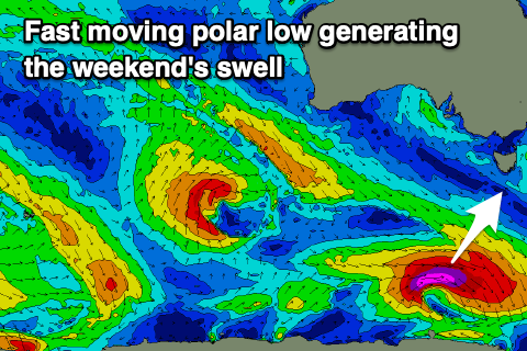
Saturday will start tiny, but our new pulse of SW groundswell from a tight, late forming polar low in our south-western swell window is on track.
A fetch of quickly moving gale to severe-gale W’ly winds should produce a good spike in swell to 2ft+ Saturday afternoon (3ft sets very likely), easing from a similar size Sunday morning.
We should see W/NW winds holding most of Saturday, with Sunday seeing great NW tending variable winds.
Make the most of this small swell as the outlook for next week is tiny thanks to mid-latitude storms continuing to move in from Western Australia, too far north of our swell window. More on this Friday.

