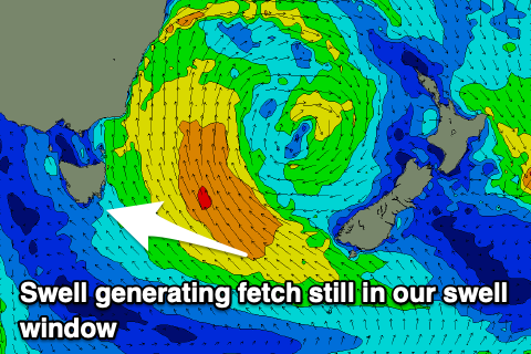
E/SE swell to persist
Southern Tasmanian Surf Forecast by Craig Brokensha (issued Monday June 17th)
Best Days: Selected spots tomorrow and Wednesday morning, Sunday morning
Features of the Forecast (tl;dr)
- Moderate sized E/SE swell for tomorrow, easing Wed and further Fri
- Light-mod W/SW-SW winds tomorrow (possibly variable W/NW at times), similar Wed but S/SW into the PM
- Fresher W/SW tending S/SE winds Thu
- S/SW winds Fri
- Small pulse of SW groundswell later Sat wiith W/NW tending W/SW winds, easing Sun with N/NW tending E/NE winds
Recap
The weekend was small and lumpy to start with, choppy and building in size through yesterday as a strong Tasman Low pushed west, back into us.
Today, onshore winds have persisted with a good pulse of E/SE groundswell, only really surfable across selected spots.
This week and weekend (Jun 18 - 23)
The Tasman Low is dominating out wind and surf outlook this week with all the energy coming from the E/SE though along with average winds.
Due to the stalling nature of the low we’ll see lingering W/SW-SW winds tomorrow that may tend variable W/NW for periods though mainly north of Clifton and not further south.
Size wise, we should see a reinforcing pulse of mid-period E/SE swell from strong E/SE-SE winds still sitting in the southern Tasman Sea this morning, maintaining 3ft sets across Clifton, bigger across more exposed breaks.

Wednesday should still be 2ft to possibly 3ft across Clifton, then easing from 1-2ft on Thursday.
Winds look similar on Wednesday, moderate W/SW but possibly shifting W/NW at times in the morning and then S/SW into the afternoon.
A fresher W/SW breeze is due on Thursday, creating average conditions and shifting S/SE into the afternoon.
Unfortunately Friday looks to see S/SW winds as a trough moves in from the west, while Saturday morning should finally offer a W/NW offshore.
Swell wise the morning looks tiny, while a slight lift in small SW swell may be seen into the afternoon, easing Sunday.
The source is a frontal system being absorbed into the westerly storm track, forming into a deep polar low south-west of us on Friday. A spike to 2ft is likely with afternoon W/SW winds, easing Sunday from a similar size with N/NW tending E/NE winds.
Longer term the outlook remains slow so try and work the current swell.

