Make the most of the current days before onshore winds dominate
Southern Tasmanian Surf Forecast by Craig Brokensha (issued Monday June 10th)
Best Days: This afternoon, tomorrow, Thursday morning selected spots
Features of the Forecast (tl;dr)
- Easing S/SW swell tomorrow with strong N tending N/NW winds, abating late
- Moderate + sized localised SW swell Wed with strong W/SW-SW winds
- Moderate + sized mid-period S/SW swell Thu with W tending W/SW-SW winds into the PM
- Easing swell Fri with strong S/SW winds
- Strong S winds all weekend with building SE swell Sun, easing Mon
- S winds Mon, Tue, variable Wed
Recap
The weekend offered small to tiny surf with morning offshores, becoming a little funky through yesterday. This morning was even smaller with clean conditions but no size.
A new swell due into this afternoon has now come right up with good 2ft+ sets and clean conditions.

New swell this afternoon
This week and weekend (Jun 11 - 16)
We’ve got an active week of surf ahead, but winds will create lots of issues.
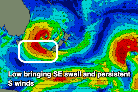
The cause will be a strong polar front pushing up and across us on Wednesday, merging with a mid-latitude low and spawning a low pressure system in the southern Tasman Sea, east of us. This low looks to stall and even retro-grade back to the west, interfering with our local winds and conditions.

Firstly, this afternoon's fun pilse of mid-period energy is due to ease, generated by a weak polar front moving under us today.
Easing 2ft+ sets are due with strong N tending N/NW winds, easing later.
These will be pre-frontal winds ahead of a strong W/SW-SW change on Wednesday as the polar front moves up and across us. A localised increase in swell is due, kicking to a stormy 3-5ft through the day, while come Thursday the stronger swell from the front proper is due.
Sets to 4ft+ should persist across Clifton, easing slowly from 3-4ft on Friday.
Now, as touched on earlier, winds on Thursday will remain less than ideal, likely moderate from the W, shifting more W/SW-SW into the afternoon, with strong S/SW winds Friday.
Unfortunately, strong S’ly winds look to persist all weekend and even into next week as the western arm of the low east of us impacts the region.
At the same time we should see moderate levels of SE trade-swell across the South Arm into the weekend and early next week, though winds don’t look to swing back offshore until maybe Wednesday. Check back here next update for the latest.

