Active outlook continues
Southern Tasmanian Surf Forecast by Craig Brokensha (issued Monday February 5th)
Best Days: Tomorrow morning, Thursday morning, Friday morning, Saturday morning, Sunday morning
Features of the Forecast (tl;dr)
- Easing surf tomorrow with W/NW winds, freshening ahead of weak sea breezes
- Inconsistent, moderate sized S/SE groundswell building Thu, peaking overnight, easing Fri
- N'ly winds ahead of freshening E/SE sea breezes and then a strong S change Thu
- W/NW tending strong S/SW winds Fri
- Large S/SW groundswell for Sat AM, easing through the day with S/SW winds
- Smaller Sun with N winds ahead of a strong S change
- Fun pulses of SW swell next week
Recap
Friday's large increase in swell eased back into Saturday but with great conditions with solid 4-5ft waves across Clifton, better at other breaks.
Yesterday saw the next pulse of strong W/SW groundswell fill in from the 'bombing' low. This was with less favourable winds and conditions though, limiting options.
Today the swell has eased but cleaned up with better 3ft sets across Clifton.
This week and weekend (Feb 6 - 11)
We're looking at easing surf after the very active period into the end of last week, but in saying that, things will pick up again into the end of the week.
Tomorrow should be easing from 1-2ft with a light W/NW breeze, freshening through the day ahead of weak sea breezes.
Wednesday looks tiny, but moving into Thursday, our inconsistent S/SE groundswell is on track. The source of this swell is a fetch of gale to severe-gale S/SE winds on the polar shelf, with a strong but inconsistent groundswell due to fill in Thursday, reaching 3ft+, then easing from a similar size Friday morning.
Winds on Thursday look good with a N'ly offshore but increasing E/SE sea breezes ahead of a S'ly change will create poor conditions as the swell builds. W/NW winds are likely Friday morning with the easing swell, though a trough will bring a S/SW change during the day.

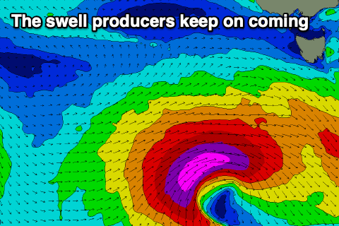
This change will be linked to a deep polar low forming south-west of us later week, with it again forming from the remnants of a tropical depression in the Indian Ocean, drifting south-east into the westerly storm track.
This will see a great fetch of severe-gale to storm-force winds firing up south-west of us on Thursday, pushing east on Friday.
The models diverge a little on the core strength of this system but we're looking at large surf on Saturday, peaking in the 6ft range across Clifton from the S/SW in the morning, easing steadily through the day.
S/SW winds look to create average conditions at the peak of the swell with N'ly winds kicking back in on Sunday with smaller 3ft+ surf.
Into next week, trailing polar frontal activity looks to bring plenty more additional swells with favourable winds. More on this Wednesday.

