Windy conditions over the coming days, better from Sunday
Southern Tasmanian Surf Forecast by Craig Brokensha (issued Friday August 4th)
Best Days: Today selected spots, protected spots for the keen tomorrow, Sunday afternoon, Monday
Features of the Forecast (tl;dr)
- Mix of W/SW and SW swells for today with strengthening N/NE tending N winds
- Easing surf Sat with gusty W/NW-W winds, easing and tending W/SW at times
- Moderate sized, SW swell for tomorrow, easing Sun
- Moderate sized SW groundswell building Sun PM with N tending variable winds, easing Mon with NW tending E/NE winds
Recap
Tiny, clean conditions yesterday with a further drop in swell from Wednesday, while today we've got a mix of new swells on the build with tricky N/NE winds. This is favouring some spots over others but Clifton is doable with 2ft+ sets. Winds should tend more N-N/NW later cleaning up Clifton.

Windy surf on the build this afternoon
This weekend and next week (Aug 5 - 11)
Today's tricky mix of swells are due to ease back through tomorrow though there'll be some new mid-period SW swell in the mix, generated by a weakening mid-latitude low dipping east-southeast across us.
A short-lived fetch of below gale-force SW winds should generate 2ft+ or so of close-range swell, mixed in with easing 2-3ft sets from today.

Winds look a little tricky, gusty out of the W to possibly W/NW through the morning, easing and tending W/SW at periods, favouring protected spots.
Sunday should be clean with N/NW tending variable winds.
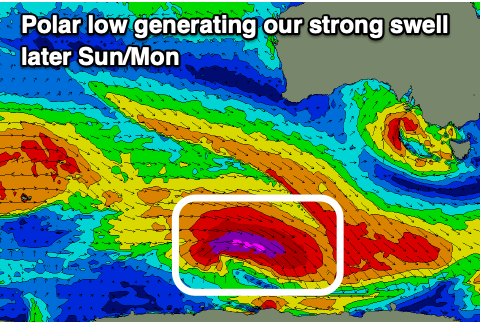
Into the afternoon, our strong pulse of SW groundswell is still on track, generated by a strong polar low that's currently south-southwest of Western Australia.
The core wind speeds have been upgraded, with gale to severe-gale W-W/NW winds sitting right on the polar shelf (even a couple of storm-force barbs registered), though weakening into this afternoon while continuing to track east-southeast.
This will produce a moderate sized, SW groundswell for later Sunday, peaking overnight, easing Monday.
Strong 3ft+ sets are due later Sunday and early Monday, smaller into the afternoon.
Sunday's variable winds will be favourable as will Monday morning with NW offshores, tending E/NE into the afternoon.
Longer term there's nothing too major on the cards at all so make the most of the coming swells. Have a great weekend!

