Surf now and tomorrow
South Australian Forecast by Craig Brokensha (issued Friday November 22nd)
Best Days: Today South Coast, tomorrow South Coast, Mid Coast for the keen Tuesday, Friday next week South Coast
Features of the Forecast (tl;dr)
- Easing SW groundswell tomorrow, with a background S/SW swell in the water, smaller Sun
- Pre-dawn SW winds tomorrow, tending light N during the AM and variable into the PM
- Moderate S winds Sun with small, fading surf
- Moderate S winds Mon
- Small-mod sized W/SW swell building Tue with E/NE tending gusty S/SE winds
- Easing swell Wed with variable N tending S/SE winds
- Moderate + sized SW groundswell building Fri with unknown winds for now
Recap
The Mid Coast was tiny and clean yesterday with little runners on the beaches on the afternoon low tide while the South Coast offered fun waves all day, 3ft or so in the morning but kicking stronger into the afternoon.
Today is the pick though with more organised, cleaner waves under a hot offshore wind while the Mid is tiny and wind affected.

Good surf this morning
This week and weekend (Nov 23 - Dec 6)
The current long-range swell will back off into the weekend and a trough moving through pre-dawn tomorrow will bring funky winds that will tend variable through the day.
We’re expecting a shallow SW change before dawn, shifting back to the N during the morning and then remaining variable through the afternoon.
Size wise, the current swell will be reinforced by a small pulse of inconsistent S/SW energy with 2ft to occasionally 3ft sets due across Middleton, easing later in the day.
Sunday looks a no go with the trough bringing a moderate S’ly wind along with small, easing levels of surf.

The Mid Coast isn’t due to see any size with tiny to flat conditions prevailing.
The start of next week looks average with onshore S’ly winds persisting along with a low point in swell.
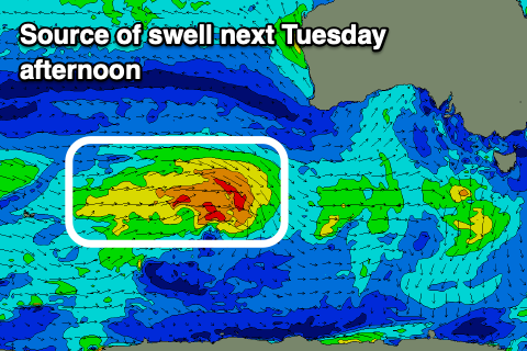
Into Tuesday, a new mid-period W/SW swell is due to fill in, generated by a small but healthy frontal system tracking from the south-west of Western Australia today, under the country on the weekend.
The size looks marginal across the Mid Coast and most likely to 1.5ft, with the South Coast seeing better 3ft waves off Middleton.

The swell will peak through the afternoon and might be a little undersized early, with light E/NE winds favouring both coasts, while Wednesday should see better, light offshore N’ly winds as the swell eases back from 2-3ft.
The wind outlook for the end of the week remains tricky thanks to a trough sitting just south-west of us. This looks to bring varying winds and swell wise, a strong polar low firing up around the Heard Island region should generate a long-range, moderate + sized groundswell for Friday.
Middleton looks to reach 4ft into the afternoon with tiny waves inside the gulf, but we’ll confirm this and the local winds on Monday. Have a great weekend!


Comments
Hey Craig what's with the latest climate driver and swell prospects? Seems all over the place at the moment.