Fun waves tomorrow
South Australian Forecast by Craig Brokensha (issued Wednesday October 16th)
Best Days: South Coast this morning, later today Mid Coast, Mid Coast tomorrow, South Coast tomorrow morning, Monday South Coast
Features of the Forecast (tl;dr)
- Moderate + sized, inconsistent W/SW groundswell building this afternoon, peaking tomorrow, easing Fri
- Variable winds across the Mid Coast tomorrow, light, local offshore down South, shifting SW late morning and then SE later
- Strong W/SW tending SW winds Fri (likely W/NW early around Victor)
- Small S/SW windswell Sat with S/SW winds down South, S/SE on the Mid in the AM
- Small W/SW swell building Sun with light local offshore winds ahead of sea breezes
- Moderate sized, inconsistent W/SW swell Mon with N/NE tending variable winds down South, E/NE tending N/NE inside the gulf
- S/SW winds Tue with easing surf
Recap
A good pulse of S/SW groundswell filled in yesterday to a slow but strong 3-4ft across the South Coast with favourable, offshore winds as the Mid Coast became tiny.
Today some inconsistent, long-range W/SW groundswell is due to build, with the South Coast again coming in clean with slower 2-3ft sets, 1ft and wind affected inside the gulf. Winds are due to go sea breezy this afternoon before tending S/SE on dark across the Mid Coast. Swell wise we should see the W/SW groundswell building to 2ft with 3-4ft sets across Middleton.
This week and next (Oct 17 - 25)
The current, building W/SW groundswell is due to peak tomorrow across both regions, with it generated by a strong low that traversed the Southern Ocean since late last week and into the start of this week.
The Mid Coast should offer inconsistent 2ft+ waves on the favourable parts of the tide, with 3-4ft sets across Middleton and the morning looks best with variable offshore winds before a weak, wandering low tries to bring a SW change late morning. This will be more for the South Coast, with the Mid likely seeing light NW winds developing through the day, then shifting E/SE-SE later afternoon. All in all there should be fun waves all day tomorrow on the Mid.
Friday will see the change proper moving through, bringing a strong W/SW tending SW breeze, though only temporary.
With this no major windswell is expected to be generated by the backside of the low, with Saturday seeing fading 2ft sets on the South Coast with S/SW winds, cleaner inside the gulf but tiny and to 1ft+.
Sunday looks cleaner in the morning down South but tiny. The Mid Coast should see some small, mid-period W/SW swell reaching 1-1.5ft, generated by pre-frontal W/NW winds ahead of a better swell producer for Monday.

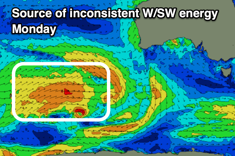
This better swell for Monday will be generated by a healthy frontal system currently moving across the Heard Island region. Fetches of strong but below gale-force W/SW winds should produce a moderate sized swell that’s due to come in at 1.5ft+ across the Mid Coast with 2-3ft waves across Middleton under a favourable N/NE offshore, tending variable into the afternoon. The Mid will be a little wind affected and best early with an E/NE offshore.
Make the most of this window of fun waves as a trough looks to bring an onshore change Tuesday with easing levels of swell. Longer term the outlook is a little flakey so check back here Friday for the latest.


Comments
Hey Craig is there another buoy we can go off in sa.
Unfortunately nothing reliable. There is the spotter buoy network but it's luck of the draw whether one of these buoys is in the Bight and right now there aren't any.. https://www.sofarocean.com/products/spotter#s-data