Good run of west swells with favourable winds
South Australian Forecast by Craig Brokensha (issued Monday August 5th)
Best Days: South Coast all period (Thursday smallest), Mid Coast Friday, Saturday and Sunday morning
Features of the Forecast (tl;dr)
- Small-mod sized SW swell tomorrow with N/NW tending NW winds
- Small-mod W/SW swell Wed with N/NW winds (N/NE early on the Mid)
- Easing surf Thu with stronger N/NW winds (N/NW windswell inside the gulf)
- Moderate + sized W/SW swell building Fri with local offshore tending weak onshore winds
- Secondary swell Sat with similar winds to Fri but with fresher sea breezes
- Easing swell Sun with N/NE tending N/NW winds
Recap
Our new pulse of W/SW swell started to show Saturday morning with clean conditions and teasing 1-1.5ft sets, pulsing to the expected 2ft+ into the afternoon but with sea breezes.
Yesterday morning was the pick with crisp 2ft waves and options all over, 2-3ft across Middleton but slow.
This morning we’ve got a tiny 1-1.5ft wave left on the coast with clean conditions, small and to 2ft down South.
This week and weekend (Aug 6 - 11)
West, west, west.
The coming period will see endless pulses of westerly swell which will favour the Mid Coast but prove tricky for the South Coast.
Ahead of this westerly run, we’ve got a better aligned SW swell due into tomorrow morning, generated by a healthy polar low that developed south-southwest of the country on the weekend.
A fun kick in size to 3ft+ is due across Middleton tomorrow morning, tiny in the gulf and with moderate N/NW tending NW winds.
Into Wednesday, a new, small pulse of mid-period W/SW-SW swell is due from a strengthening frontal system moving in from the west today and tomorrow. This system looks weak and not too ideal but should provide 1-2ft sets on the Mid Coast with the South Coast coming in at 2ft to possibly 3ft.
Conditions will be best on the South Coast again Wednesday with a N/NW breeze that will likely tend N/NE for a period inside the gulf.
Thursday will become choppy inside the gulf with stronger N/NW winds, while the South Coast will be cleaner but small and fading.
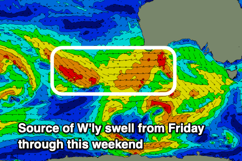
The next pulses of swell are due from the west from Friday through the weekend thanks to a progression of strong but very northward positioned frontal systems up towards the Indian Ocean, tracking east-southeast on approach to Western Australia and being deflected further away from the Bight thanks to high pressure over the south-east.

These will favour the Mid Coast but come in smaller and inconsistent across the South Coast.
The first pulse of energy for Friday should come in at 2-3ft through the afternoon across the Mid Coast, holding a similar size Saturday and then easing on Sunday.
Middleton looks to come in mostly around 3ft, with the odd bigger one possible Saturday but we’ll review this on Wednesday.
Looking at the local winds and we’re looking at variable offshore tending variable sea breezy on Friday, with similar winds Saturday but with slightly stronger sea breezes.
Sunday will become a little more wind affected on the Mid Coast with a N/NE tending N/NW breeze, best down South.
Following pulses of swell looks smaller and less favourably aligned for early next week but with northerly winds which will favour the exposed breaks down South. More on this Wednesday.

