Small to tiny surf, large and windy late next week
South Australian Forecast by Craig Brokensha (issued Friday 5th July)
Best Days: South Coast magnets Sunday morning and Monday, Thursday morning protected spots South Coast
Recap
Wednesday's pumping day of waves eased off into yesterday on the Mid Coast leaving fun 2ft sets through the morning, 1-1.5ft into the afternoon. The South Coast saw easterly winds and not the best conditions. Today is much better with cleaner conditions and small 2ft waves off Middleton, better at Waits and Parsons. The Mid Coast is clean but back to 0.5-1ft.
Today’s Forecaster Notes are brought to you by Rip Curl
This weekend and next week (Jul 6 – 12)
The weekend will be generally small to tiny, best Sunday with an increase in new inconsistent W/SW groundswell.
Tomorrow will be clean again down South with a moderate to fresh N/NE breeze, but the swell tiny and easing. Middleton will be great for beginners and 1ft or so, while desperate surfers should try Waits and Parsons. The Mid Coast will be tiny to flat.
 A new very inconsistent W/SW groundswell is due to arrive later in the day Saturday and peak Sunday, generated in our far swell window earlier this week.
There's been no change to the size of this swell with only an infrequent 2ft+ wave due along the Middleton stretch, with 1-1.5ft sets on the Mid Coast on the favourable parts of the tide. Unfortunately winds will become average on the Mid but be good for the South Coast through the morning with a NW offshore, shifting W/NW early afternoon and then SW.
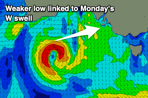
The additional W/SW swell from the small mid-latitude low looks average at best, with the fetch being tight and not overly strong.
We'll likely see the Mid Coast hanging in around 1-1.5ft Monday morning, easing later, with easing 2ft sets off Middleton. Conditions looks favourable across both coasts with a variable breeze on the Mid, light NW into the afternoon and variable tending NW down South.
Following this there's nothing significant on the cards until later next week, and we might be looking at a significant stormy swell across the state.
A strong node of the Long Wave Trough will move in and stall across the south-east corner of the country, directing a flurry of strengthening storms up and into us and Victoria.
Current forecasts aren't quite aligned, but GFS has gone all in on it's 18z run with storm to hurricane-force W/SW winds expected to be projected up through our south-western swell window. We'll take this with a pinch of salt at this stage, but ECMWF has a similar but weaker progression, projecting more into us. Either way we're looking at large windy surf to end the week, but we'll have to nail down the specifics on Monday. Have a great weekend!


Comments
Small clean lines from Day Street to Goolwa this AM.
