Clean easing surf, slower until late next week
South Australian Forecast by Craig Brokensha (issued Wednesday 19th June)
Best Days: Both coasts tomorrow (Mid Coast AM) and swell magnets Friday morning, South Coast Sunday and Monday morning, later next week
Recap
Poor conditions across all locations yesterday with a stiff onshore wind and new large but inconsistent SW groundswell to 4ft off Middleton and 2ft on the sets across the Mid Coast.
Today conditions were much cleaner across all locations and our secondary larger pulse of W/SW groundswell filled in with solid 4-5ft sets off Middleton and other breaks down South with improving conditions, while the Mid Coast was around 2ft.
The swell has eased slightly down South but cleaned up further, while the Mid Coast is average and bumpy.
Today’s Forecaster Notes are brought to you by Rip Curl
This week and weekend (Jun 18 - 23)
From here on the surf will drop down and down into the start of the weekend.
Tomorrow morning should still hopefully reveal 3-4ft waves across the Middleton to Goolwa stretch, while the Mid Coast looks to ease back from 1-2ft.
Friday will become smaller with fading 2ft sets off Middleton, tiny on the Mid and tiny across all locations Saturday morning.
Winds are now looking better for the South Coast through the whole period, with a great persistent offshore from the N/NE tomorrow, tending N/NW further west of Victor. The Mid should be clean again with a morning NE offshore.
Friday will see winds go more NE to E/NE, not the best and cleanest at spots that offer protection from this wind or face more south-west.
NE-E/NE winds will persist Saturday morning but with a tiny swell, onshore into the afternoon as signs of a new inconsistent long-range SW groundswell start to show.
This new inconsistent and long-period SW groundswell due will be a classic example of the peak in groundswell energy occuring some 24+ hours behind when the long-period forerunners hit the buoys.
The reason for this is that the swell was generated so far in our western swell window, south-east of South Africa, with a persistent fetch of storm-force W'ly winds generating the really long periods. As these travel faster through the deep ocean compared to the rest of the swell, and the distance in which this swell is travelling is so far, we'll see the fore-runners likely hitting the Cape du Couedic wave buoy later Friday, ahead of the swell proper later Saturday but more so Sunday. This is explained in more detail in an article I did 8 years ago.. Why The Swell Train Is Often Late.
Middleton should build to an infrequent 2-3ft later Saturday but with sea breezes, peaking Sunday morning to 3ft, while every 15-20minutes we may see the odd 4ft set. The Mid Coast will remain tiny and to 1ft.
 Winds on Sunday morning look good and from the NE-N/NE, tending E/NE into the afternoon, with Monday seeing smaller easing waves under a great N/NE tending N/NW offshore.
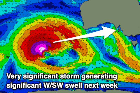
As touched on last update the surf will remain on the small side through most of next week ahead of a significant long-period W/SW groundswell later in the week.
This swell will be generated by a very broad, strong and slow moving storm developing north of the Heard Island region on the weekend. An initial fetch of severe-gale W/SW winds will set in motion an active sea state for a slow moving fetch of storm-force W/SW winds to move over, projecting slowly east-northeast directly through our western swell window.
A blocking high will keep the storm at arms length to us though, but result in offshore N/NE winds as the swell builds Thursday afternoon and peaks Friday.
Size wise as a rough guess it looks like we'll see 3ft surf on the Mid Coast and 4-5ft waves down South, but more on this Friday and early next week.


Comments
So blurry..