Ments: Large swell Friday, slow period until next Thursday
Nias, Mentawai, South Sumatra forecast by Craig Brokensha (issued Thu 10th Jul)
Best Days: Friday through Monday, Thursday onwards next week
This Friday onwards (Jul 11 onwards)
A reinforcing S/SW groundswell should of arrived yesterday and kept good waves hitting exposed spots this morning as N/NW winds limited options.
Of greater importance though is a large S'ly groundswell due across the region tomorrow, generated by a vigorous polar frontal progression forming on the periphery of our swell window, in the Heard Island region before pushing north-east towards WA over the weekend and early this week.
This swell should arrive overnight and peak tomorrow morning to 6-8ft+ across exposed south facing breaks in the Ments, with less size around Nias (peaking into the afternoon) and bigger 10ft sets around South Sumatra.
Winds should become variable around the Ments tomorrow with slightly stronger E/SE trades in Southern Sumatra while Nias looks to see less favourable NW winds strengthening as a weak trough sits just west of the region.
After tomorrow's swell it's all down with nothing significant until later next week when a large S/SW groundswell is on the cards.
A low point in activity is due through Monday, Tuesday and Wednesday morning.
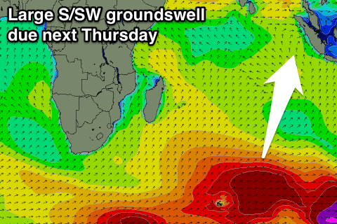
 The large S/SW groundswell due through Thursday and Friday next week linked to an amplification of the Long Wave Trough moving through the Southern Indian Ocean. This should project two vigorous polar fronts up from the south-east of South Africa, up and over Heard Island into tomorrow and the weekend before tracking westerly across to Western Australia.
A large S/SW groundswell will result, with the forerunners arriving later Wednesday ahead of the bulk through Thursday, peaking through the day. We're probably looking at a peak in the 8ft+ range across the Ments with the odd bigger bomb possible, with 8-10ft+ waves in South Sumatra. Nias will be smaller and more in the 6-8ft range.
Winds at this stage are looking generally variable if not from the NW, but we'll review this Tuesday.
16 day Mentawai forecast graph
16 day Nias forecast graph
16 day South Sumatra forecast graph


Comments
:)
In the airport & off to the Telos, 6ft is what I wanna hear :-)
In the airport & off to the Telos, 6ft is what I wanna hear :-)
Latest updates have those unfavourable NW winds becoming fresh and extending down to the Ments through the weekend now. This will limit options more to breaks on the southern and south-eastern sides of the islands.
Those winds in South Sumatra too Craig?
Into Sunday yes, but the system looks to weaken into Monday morning with a return to light-moderate E/SE winds Monday arvo onwards.
Ok cool, thanks. Hopefully clean by the Thusday swell. Pretty excited...
Yeah definitely clean by then and pumping. Have a look at the forecast chart...
Unreal!