Ments: Large swells Friday/Monday, smaller from the south onwards
Nias, Mentawai, South Sumatra forecast by Craig Brokensha (issued Thu 3rd Jul)
Best Days: Every day over the coming period
This week and weekend (Jul 4 - 6)
A low point in swell activity should have been seen this morning, but from here on into the weekend and next week, there's plenty of swell on the cards.
Later today we should see the start of a large S/SW groundswell filling in ahead of a peak tomorrow morning. There's been no change to the expected size with exposed spots in the Ments due to offer 6-8ft+ sets, with 6-8ft surf around Nias and more consistent sets above 8ft in Southern Sumatra.
Winds should be light and variable for the most part, opening up plenty of options for a wave.
A drop in size is due into the afternoon and further over the weekend, from 6ft+ or so Saturday morning and then down to 4-5ft into Sunday.
Next Monday onwards (Jul 7 onwards)
Another slightly larger S/SW groundswell is due Monday next week, generated by a vigorous polar front firing up south-east of Madagascar and pushing above Heard Island the last couple of days.
This frontal system is the first in a series of about three that will fall under the influenced of a strong node of the Long Wave Trough pushing slowly east through the Southern Indian Ocean.
Size wise, this first S/SW groundswell should come in a touch bigger than tomorrow's pulse with more consistent sets around 8ft and possibly above before easing into Tuesday. Winds are expected to be variable in the Ments but fresh E/SE trades are due around South Sumatra.
A reinforcing S/SW groundswell is then due to build Wednesday, generated as a secondary smaller but strong polar front pushes up quickly in the wake of the original swell generating system.
This should see exposed spots kicking back to 6ft+ Wednesday afternoon and Thursday morning under light variable winds from the N'th if anything.
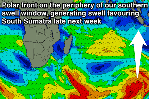
 One final pulse of S'ly groundswell is due into the end of the week from a third polar front, but this system will form late in our swell window and push up towards WA as the LWT moves slowly across Australia.
Only medium-large sized levels of side-band energy are due into Friday at exposed south facing breaks, with South Sumatra picking up the most size. The Ments should offer 4-6ft sets before easing back slowly into Saturday, smaller around Nias and much larger to 8ft to possibly 10ft in South Sumatra at exposed south facing breaks.
Winds through Friday afternoon look to become funky around the Ments though as a weak trough deepens slightly off the region, bringing freshening NW winds that will persist into the weekend, but we'll review this Tuesday.

